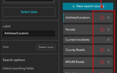
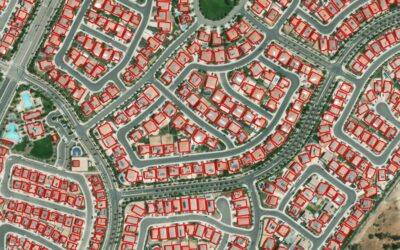
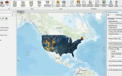
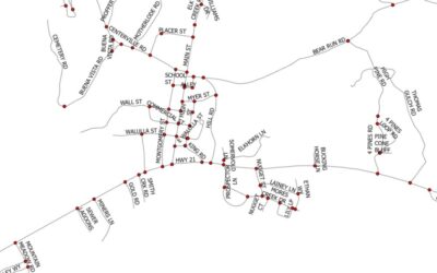
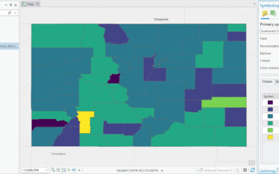
ArcGIS Pro offers some powerful functionality to map population density. In this tutorial, we’ll use population density data from the European Union to map population density values using the Natural Breaks (Jenks) method of classification. This method of...
Articles & Tutorials
Tutorial: Use a Vector Basemap Editor in ArcGIS Online to Customize a Basemap
ArcGIS Online doesn’t make it incredibly clear that you can create a custom basemap for use in Map Viewer. Within the map viewer itself, there are small adjustments you can make from the basemap details and settings panel, such as darkening the hillshade layer through...
Tutorial: Customize a Label Class with Python in ArcGIS Pro
In this tutorial, you’ll learn how to measure distances of rivers and use Python to show these on a map using a label class. ArcGIS Pro offers flexible labeling capabilities to communicate multiple properties of a single feature to the map reader. Here, we’ll use a...
Tutorial: Creating Custom Basemaps with ArcGIS Pro
In this tutorial, you’ll learn how to create a custom basemap with ArcGIS Pro and add it to the default basemap gallery in Pro so you can use it for other projects. There are two ways to do this. First, we create an empty basemap and add data to it. Next, we’ll...
Expert Maps with Layer Blending: Free Blend Mode Guide
Do you feel like you spend too much time on reordering and adjusting transparency of layers just to show overlapping features, such as hillshade? If this issue is still haunting you, then you must not have moved on to ArcGIS Pro or the new Map Viewer, yet, where you...
Annual Holiday Sale- November 21st – December 31st
Our annual holiday sale begins today! To celebrate our 17th year in business, Geospatial Training Services will be offering a 17% discount on many of our training products including: In-person trainingLive-online trainingSelf-paced trainingSelf-paced...
What is Smart Mapping and Why Should I Use It?
The new Map Viewer in ArcGIS Online has cranked up the power of visualization with a Smart Mapping turbocharge. Smart Mapping techniques were integrated into the ArcGIS Online (AGOL) platform in 2015, which means some techniques were available for use with Map Viewer...
Tutorial: Catalog and Find Geospatial Data with Python
In this tutorial, you’ll learn how to catalog data using Python. Specifically, we’ll use the arcpy and os modules to move through a directory tree to catalog and find data. The os module is used to interact with your operating system, move through a directory and find...
Tutorial: Adding Data to a Map in ArcGIS Pro with Python
In this tutorial, you’ll learn multiple ways to add data to a map using Python. Specifically, we’ll add single shapefile feature classes and folders containing shapefile feature classes to the map using both arcpy and the os module. There are various ways to add data...
Create a Script Tool in ArcGIS Pro from a Python Script
In this tutorial, you’ll learn how to create a script tool in ArcGIS Pro from a standalone Python script. A script tool is a Python script file that can be run as a geoprocessing tool. This means you only have to worry about setting the right parameters of the tool...