
")
Check out our upcoming in-person ArcGIS Pro training in Denver, Billings, MT and other locations.
The “Select by Location” tool in ArcGIS Pro is a powerful feature that allows users to select features based on their spatial relationships to other features within the same or a different layer. This capability is crucial for GIS professionals and analysts who need to conduct spatial analyses, create maps, or manage geographic data more efficiently. In this article, we will delve into the functionality, applications, and benefits of using the “Select by Location” tool in ArcGIS Pro.
Understanding the “Select by Location” Tool
The “Select by Location” tool in ArcGIS Pro enables users to perform selections of features based on spatial relationships such as containment, proximity, intersection, and overlap with other features. This tool can be accessed from the “Selection” menu in ArcGIS Pro and offers various options for specifying the type of spatial relationship, the input feature layer, and the selecting features layer.
You can also watch our companion YouTube video on this topic. Please be sure to like and subscribe!
Key Features
- Spatial Relationship Criteria: Users can specify the spatial relationship criteria such as intersect, contain, are contained by, touch, overlap, are within a distance of, or completely within the selecting layer.
- Multiple Layer Selection: It allows for the selection of features across different layers, enabling complex spatial analyses.
- Selectable Layers Configuration: Users can configure which layers are selectable, enhancing the tool’s flexibility and user control over the selection process.
Applications
The “Select by Location” tool has a wide range of applications across various fields such as urban planning, environmental management, public safety, and more. Here are a few examples:
- Urban Planning: Identifying buildings within a floodplain for risk assessment.
- Environmental Management: Selecting protected areas that intersect with proposed development sites.
- Public Safety: Identifying areas within a specific distance of critical infrastructure for emergency response planning.
Benefits
- Efficiency: The tool streamlines the process of selecting features based on spatial relationships, saving time and effort in data analysis.
- Accuracy: By allowing precise selection criteria, it ensures high accuracy in the selection process, leading to more reliable results.
- Versatility: Its applicability across various fields and for different types of spatial analyses makes it an indispensable tool for GIS professionals.
How to Use the “Select by Location” Tool in ArcGIS Pro
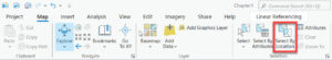
1. Access the Tool: Navigate to the “Map” tab, then in the “Selection” group, and click on “Select by Location.”
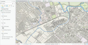
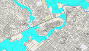
In this example we will find features from the City Parcels layer that intersect features from the Rivers and Streams layer.
2. Specify Selection Parameters: Choose the input feature layer you want to select features from, and the selecting layer that contains the features used to select the input features. Then, specify the spatial relationship. In the example below we are selecting City Parcels that intersect the Rivers and Streams layer.
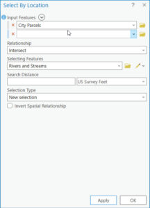
3. Execute the Selection: After configuring the selection criteria, click “OK” to run the tool and perform the selection based on the specified spatial relationship.
Tips for Effective Use
- Layer Preparation: Ensure that your layers are correctly prepared and projected for accurate spatial analysis.
- Spatial Relationship Understanding: Familiarize yourself with different spatial relationships to select the most appropriate one for your analysis.
- Selection Refinement* Use additional tools and criteria to refine your selection for more precise analysis outcomes.
Conclusion
The “Select by Location” tool in ArcGIS Pro is a cornerstone feature for GIS professionals, offering the ability to perform complex spatial selections efficiently and accurately. By understanding its features, applications, and benefits, users can leverage this tool to enhance their spatial analysis workflows and achieve more informed decision-making based on geographic data. Whether for urban planning, environmental management, or public safety, the “Select by Location” tool provides a robust solution for exploring spatial relationships and patterns within geographic datasets.
