

ArcGIS Online offers 70+ pre-trained AI models that can be used for different ArcGIS platform configurations for tasks such as digitizing and extracting features from imagery and point cloud datasets.
Esri’s Living Atlas of the World offers maps, apps, and data layers to support GIS users. It also offers 72 pre-trained AI models for performing a variety of tasks including analyzing, interpreting, and making predictions based on spatial data. These models can be seen as AI best practices for existing GIS workflows and applications. They can be downloaded for personal use, for example inside ArcGIS Pro in combination with its deep learning tools for imagery, point cloud, text, and time series data.
Ready-to-use AI models
The main benefit of using these pre-trained AI models is takes the time and effort to train a deep learning model yourself. Instead of building and refining a deep learning model from scratch (which requires large volumes of training data and compute resources), the pre-trained AI models from Esri’s Living Atlas of the World have been trained extensively and produce good results. They take away the need to do labeling, training and other data science tasks, and can be used directly as part of running a GeoAI geoprocessing tool inside Pro when downloaded.
Getting started
To access these pre-trained AI models, login to the ArcGIS Living Atlas of the World website and run a search query on “deep learning”. This will result in a total of 72 deep-learning models. Many of the search results are deep learning models to detect and extract specific features inside imagery, such as building footprints or swimming pools. The individual models can be downloaded and stored on a local computer so they can be referenced as part of the different input and output parameters when running deep learning tools in Pro.
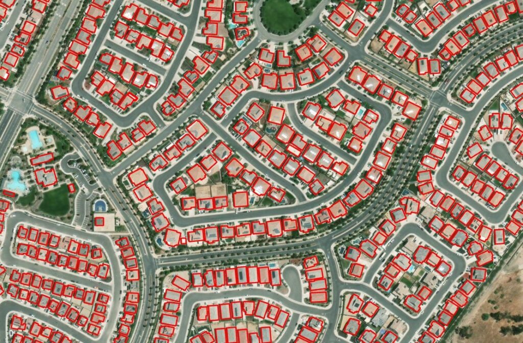
Each of these models works with specific geographies, imagery types, and resolutions. For example, AI-based land cover mapping workflows require different deep learning tools depending on the imagery types used for land cover classification (high-resolution, medium-resolution, and low-resolution imagery). When working with imagery and/or 3D point clouds in Pro, additional product extensions are required.
Applying and Extending Meta’s Segment Anything Model (SAM)
With so many models to choose from that only meet the requirements of specific use cases, it’s no surprise that one of the most popular pre-trained AI models inside ArcGIS Online is Meta’s Segment Anything Model (SAM) for segmenting objects in any imagery. As the name implies, the model can segment any object and is therefore useful for many different workflows and use cases. Segmentation models perform a pixel-wise classification by classifying pixels into different classes, and the classified pixels correspond to different objects or regions in the image.
Esri recently announced ways to extend the functionality of SAM to meet the needs of specific use cases. For example, the Text SAM deep learning package combines SAM with Grounding Dino, a model for detecting objects through text prompts. This allows you to detect objects inside imagery through text prompts. The SAMLora model combines SAM with the LoRA training technique that reduces the number of training parameters which speeds up the feature extraction process significantly with great results.
