

ArcGIS Pro 3.7 added a new Embeddings Based Analysis toolset to the GeoAI toolbox. It’s a small toolset, only four tools, but it brings a technique that has been reshaping AI in other fields into everyday GIS work.
This article covers what embeddings are in plain terms, what each tool does, the licensing and setup you’ll need, the places people get stuck, and whether any of this is worth your time yet.
What Is an Embedding?
Think of an embedding as a fingerprint for something complicated.
In normal GIS work, you describe a place with separate attributes: population density, median income, percent tree cover, building count, and so on. To compare two places, you have to decide which attributes matter and how much weight each one gets. With imagery it’s worse, since raw pixel values rarely compare cleanly across scenes, seasons, or sensors.
An embedding takes all that information and compresses it into a fixed-length list of numbers. Esri’s USA Geodemographic Embeddings, for example, use 256 numbers per location. A model learns to place similar things close together in that numerical space and dissimilar things far apart.
Two neighborhoods with similar demographic, housing, and environmental profiles end up near each other. Two patches of satellite imagery showing similar patterns end up near each other too, though that depends heavily on the model, the sensor, band configuration, resolution, season, and how the imagery was processed.
This makes a few things much easier:
- Similarity search. Find places, or image areas, like this one.
- Pattern discovery. Surface relationships you’d struggle to write rules for.
- Aggregation across scales. Roll fine-grained information up to larger units and still get a representative vector.
- Feature engineering. Use the embedding as a ready-made input to a model instead of assembling hundreds of variables.
One thing that trips people up: individual embedding dimensions don’t mean anything on their own. Dimension 47 is not income. Dimension 112 is not vegetation. The information is spread across the whole vector, which is why Esri’s guidance is to use all dimensions together and never interpret one in isolation.
Two flavors show up in the current tools. Imagery embeddings capture visual patterns, textures, and semantic content from satellite or aerial imagery. Location embeddings capture the broader character of a place, including demographics, socioeconomic factors, and environment.
The Ready-Made Layer: USA Geodemographic Embeddings
If you want to try embeddings without generating any, start here. Esri published a beta USA Geodemographic Embeddings layer to ArcGIS Living Atlas. Sign in with your ArcGIS Online credentials to access it. Note: You will need to be using ArcGIS Pro 3.7 to add this layer to a map.
The layer holds 256-dimensional vectors for every Uber H3 resolution 7 hexagon across the contiguous United States and Alaska. Each hexagon covers roughly 5 square kilometers.
Those vectors come from Esri’s Geodemographic Foundation Model, a multiview autoencoder trained on about 5,300 variables drawn from the 2000 through 2020 Censuses, ACS 2019 through 2024, household housing data, and USA environment data. Each dataset is encoded separately, concatenated into a 256-dimensional vector, and reconstructed through a decoder. What survives that compression is the pattern structure, not the individual variables.
Most downstream work with these embeddings runs fine on standard CPU hardware. You only need serious GPU horsepower when you’re generating embeddings yourself.
The Four Tools
Generate Embeddings Using AI Models
The starting point. It converts imagery, geographic features, or text into embedding vectors using pretrained foundation models.
Models come in as ArcGIS deep learning packages (.dlpk) or Esri model definition files (.emd), stored locally or pulled from Living Atlas. Current options include the Global Location Encoder for locations, and Prithvi EO 2.0, Clay, TerraMind, DOFA, and DINO for imagery. Each has its own input requirements. DINO expects RGB. Prithvi EO 2.0 expects a specific multispectral band arrangement. Feeding a model the wrong band setup produces embeddings that are technically valid and analytically meaningless.
Two arguments matter and are easy to miss:
- Grid Size applies to raster inputs. It sets the size of the area, in meters, that each embedding covers. One embedding per grid cell.
- Text Field names the field whose values get turned into embeddings when you’re working with text.
Output is a feature class with an Embedding BLOB field. The tool runs on CPU or GPU, but this is real deep learning inference and a GPU makes a large difference. Set the Processor Type environment to GPU, or specify a GPU ID if you have more than one card.
Find Similar Features Using Embeddings
This is the payoff tool. Give it an embeddings feature class as the search space and one or more query features representing what you’re looking for. It builds a representative vector from the embeddings intersecting your query geometry, compares it against everything in the search space using cosine similarity, and writes out everything above a similarity threshold you set, with a score attached.
There’s also an interactive Find Similar pane for quicker exploration without configuring a geoprocessing tool.
A concrete use: you spot one damaged area in post-disaster imagery, and the tool finds every other area across a large collection that looks similar. That only works if the embeddings across that collection came from the same model with consistent processing.
Merge Embeddings
Aggregates embeddings from a finer source layer into larger target polygons. Hex bins into counties, ZIP codes into states, image patches into watersheds.
The math changes with geometry type. Points into polygons uses a simple arithmetic mean, treating each point as an equal observation. Polygons into polygons uses an area-weighted average, so a source polygon covering 90 percent of a target has far more influence than one covering 10 percent.
For the area-weighted case, set a projected coordinate system in the Output Coordinate System environment. Running it in WGS84 gives you slower performance and less accurate area ratios.
Skip memory and in_memory workspaces here. Embedding datasets get large and RAM consumption climbs fast.
Extract Embedding To Fields
Embeddings are stored efficiently as BLOBs, but most ArcGIS tools want plain numeric fields. This tool expands each embedding into individual Float32 fields, one per dimension, using a prefix you supply. A prefix of embed_ on a 256-dimensional embedding gives you embed_1 through embed_256.
The original BLOB field and all other attributes are preserved. Keep an ID or category field around, because 256 columns of unlabeled floats are impossible to interpret otherwise.
Once extracted, the fields feed directly into tools you already know: Multivariate Clustering, Similarity Search, Dimension Reduction, and Forest-based and Boosted Classification and Regression.
Setup, Licensing, and Storage
Deep learning libraries are required. Every tool in the GeoAI toolbox needs the deep learning frameworks installed. That’s a separate installer from ArcGIS Pro itself and version-matched to your release. Get this done before anything else.
Licensing is stricter than you’d expect:
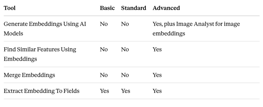
Note the first row carefully. Advanced is the floor for all embedding generation, and Image Analyst is an additional requirement layered on top when your input is imagery. Image Analyst on a Standard license won’t get you there.
Storage has hard limits. Embeddings must live in a file, mobile, or enterprise geodatabase. Shapefiles and GeoPackages can’t handle the BLOB storage and aren’t supported.
The field name is not optional. For a feature class to be recognized as an embeddings dataset, it needs a field named exactly Embedding with type BLOB. Merge Embeddings looks for that specific name. If you’re bringing embeddings in from outside ArcGIS, serialize them as float32 binary arrays and name the field correctly, or nothing downstream will see them.
Access from the ribbon: Analysis tab, Workflows group, Embeddings button. That gets you Generate Embeddings, the Find Similar pane, and Merge Embeddings. Everything else is in the GeoAI toolbox.
Where People Get Stuck
Embedding spaces are model-specific. Vectors from two different models don’t belong in the same space even when they have the same number of dimensions. Comparing them produces numbers that look like similarity scores and mean nothing. Same model, same processing, or don’t compare.
Mismatched dimensions behave differently in different tools. Merge Embeddings skips bad records and issues a warning, so you can lose data quietly. Extract Embedding To Fields fails outright and reports the ObjectID of the offending feature. Extract also fails if any embedding value is null. Merge, by contrast, writes a null Embedding for any target polygon that no source feature intersected. Check your output for nulls before assuming a run succeeded.
Similarity is not explanation. A high score tells you the model considers two places alike. It doesn’t tell you why, and it can’t tell you which real-world characteristic drove the judgment. Before any result informs a policy, investment, or operational decision, go back to the source data and look at the actual variables.
Everything upstream still applies. Embeddings inherit whatever limitations came with their training data: geographic coverage, imagery resolution and acquisition conditions, how current the data is, model bias, grid size, and the modifiable areal unit problem. Validate against cases you already know the answer to before you operationalize anything.
Change detection is a maybe. Comparing embeddings from two dates can flag semantic differences, and that’s genuinely useful for narrowing down where to look. It is not equivalent to a purpose-built change detection workflow. It’ll tell you something changed without telling you precisely what or exactly where.
Getting Started
- Confirm ArcGIS Pro 3.7 or later, an Advanced license, Image Analyst if you’re working with imagery, and the deep learning frameworks installed.
- Add the Living Atlas USA Geodemographic Embeddings layer and explore it. No generation required, and you’ll learn the concepts on real data.
- Run Extract Embedding To Fields on a county’s worth of hexagons, then feed the results into Multivariate Clustering. This is the fastest way to see embeddings do something you couldn’t easily do before.
- When you’re ready to generate your own, start small. One test area, a model matched to your data type, and a careful check of the band requirements.
- Try Find Similar Features Using Embeddings, and look at both the scores and the underlying source data for your top matches.
Is It Worth It?
For most GIS teams, not yet as a production workflow. The licensing requirement puts it out of reach for a lot of shops, and generating your own embeddings needs a GPU and a working understanding of which foundation model fits your imagery.
But the ready-made geodemographic layer is a different story. It runs on CPU, it costs nothing beyond your Living Atlas access, and it lets you ask “find me places like this one” across the entire country without building a variable list first. For site selection, market analysis, or any work where you’re currently hand-picking and weighting demographic variables, that’s worth an afternoon of your time.
The larger point is where this is heading. Esri is clearly building toward a platform where pretrained models do the feature engineering and analysts spend their time on questions instead of variable selection. The 3.7 toolset is early, but it’s a real signal about what GIS work is going to look like.
Full details are in the ArcGIS Pro help under Embeddings and the GeoAI toolbox reference.
