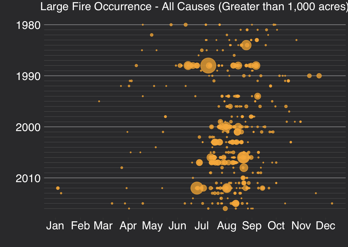
Articles & Tutorials

Visualizing Large Wildfire Activity in Montana from 1980-2016

Visualizing Large Wildfire Activity in Montana from 1980-2016

The 2017 wildfire season shattered records and cost the U.S. Forest Service an unprecedented $2 billion. From the Oregon wildfires to late season fires in Montana, and the highly unusual timing of the California fires in December, it was a busy year in the Western...

read more
Free Chapter: Data Visualization and Exploration with R

Free Chapter: Data Visualization and Exploration with R

My latest book, Data Visualization and Exploration with R, has been published, and you can download a free chapter.  The book is available in both hard copy and digital formats.  You will also want to download and install the exercise data.  This book uses RStudio, so...

read more
Accessing Geospatial Data with PyShp, Shapely and Fiona

Accessing Geospatial Data with PyShp, Shapely and Fiona

The new 1.5 version of the ArcGIS API for Python integrates the PyShp, Shapely and Fiona packages, so that vector data from other libraries can be accessed through the API as well. Let’s have a look at the these three Python libraries and how they are used within the...

read more
New ArcGIS Pro Class Bundle

New ArcGIS Pro Class Bundle

Our new ArcGIS Pro Class Bundle gives you self-paced, online access to 6 ArcGIS Pro classes for one low price of $499/student.  This bundle includes the following classes:

read more
Introducing Spatially Enabled DataFrames

Introducing Spatially Enabled DataFrames

The new 1.5 release of the ArcGIS API for Python finally allows users to read spatial data as pandas DataFrame objects. As a result, manipulating geometric and attribute information of spatial data has become a lot easier. Although previous versions of Esri’s ArcGIS...

read more

Video: Adding Symbol Styles to ArcGIS Pro

ArcGIS Pro only loads a limited number of symbology styles which may not allow you to create the cartographically pleasing maps you wish. Have no fear. You can add more styles to ArcGIS Pro to increase your symbology selection. https://youtu.be/iBfmcbsZg2A Upcoming...

read more

New Book – Data Visualization and Exploration with R

My new book, Data Visualization and Exploration with R, is scheduled for publication on September 20th, 2018.  Our newest class, Introduction to R for Data Visualization (Charts, Graphs, and Maps), is also based on this book. You can pre-order a digital version of the...

read more
Using the ArcGIS Pro Firefly Style for Data Visualization

Using the ArcGIS Pro Firefly Style for Data Visualization

Esri recently released a new visualization style and supporting basemap for ArcGIS Pro that you're going to want to check out.  The new Firefly style and supporting basemap can be used to create really attractive thematic visualizations.  In this article I'll show you...

read more

Categories

Recent Posts

Sign up for our weekly newsletter
to receive content like this in your email box.