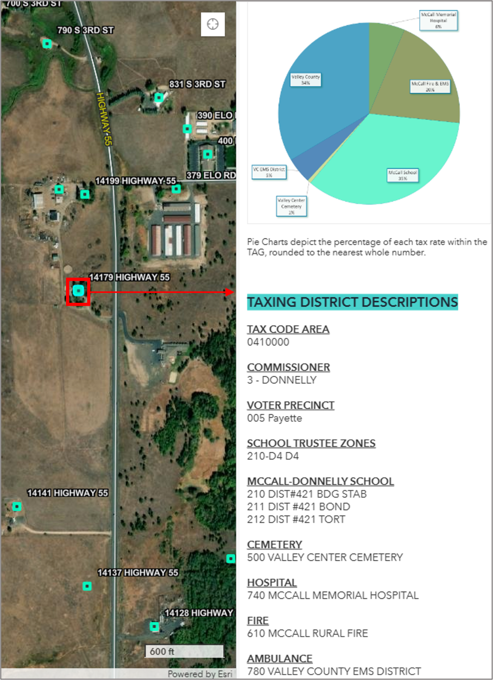
Articles & Tutorials

Combining Multiple Spatial Analysis tools in ArcGIS Pro

Combining Multiple Spatial Analysis tools in ArcGIS Pro

The following tutorial uses multiple spatial analysis tools to be able to compare population counts for the four different regions in the US. When doing spatial analysis, you often must combine multiple tools to be able to find a solution to a specific problem. This...

read more
Tutorial: Mapping Migration Flows with R

Tutorial: Mapping Migration Flows with R

The American Community Survey Migration Flows dataset estimates the number of people that have moved between pairs of places. The estimates are calculated based on where a person lived when surveyed and where they lived one year prior to being surveyed. The data is...

read more
ArcGIS Pro 2.8’s New Copy Python Command

ArcGIS Pro 2.8’s New Copy Python Command

ArcGIS Pro 2.8 comes with a new handy feature that copies the Python command when running a geoprocessing tool inside Pro. This tutorial shows how the tool works, describes some best use cases and how the interpret the results. Pro 2.8 introduces a new handy feature...

read more
Mapping Population Growth Hot Spots with R and ArcGIS Pro

Mapping Population Growth Hot Spots with R and ArcGIS Pro

This tutorial demonstrates how to use R and ArcGIS Pro to generate hot spot maps of population growth by census tract. In a previous article I showed you how to use the tidycensus R package to quickly access and map US census data. You can also download a free copy of...

read more
ArcGIS Pro 2.8 Data Engineering Tutorial

ArcGIS Pro 2.8 Data Engineering Tutorial

ArcGIS Pro 2.8 comes with a new Data Engineering toolset. This tutorial demonstrates how to get started using data engineering in ArcGIS Pro. To follow along with the steps in this tutorial, download the Natural Earth quick start kit and create a new folder connection...

read more
Using an Arcpy UpdateCursor to Edit an Attribute Table

Using an Arcpy UpdateCursor to Edit an Attribute Table

In this tutorial, we will be using an UpdateCursor object to edit an attribute table. Specifically, we will join field values from three separate fields to a single field value and apply string formatting for each iteration of the cursor object. An arcpy UpdateCursor...

read more
Using a Where Clause Inside a SearchCursor to Filter Data

Using a Where Clause Inside a SearchCursor to Filter Data

In this tutorial, we will be using using SearchCursors with a where clause used as an optional parameter. We will explain the function of where clauses and their syntax when creating a SearchCursor object with arcpy. What is a where clause? When you look at the syntax...

read more
Videos: Working with Charts in ArcGIS Pro

Videos: Working with Charts in ArcGIS Pro

Charts can be created in ArcGIS Pro from tabular data as well as raster data.  Tabular data includes feature data such as feature classes or shapefiles along with standalone tables.  Raster data, including imagery and pixel data, can also be used as a source...

read more
Adding Arcade Expressions to Pop-Up Windows in ArcGIS Pro

Adding Arcade Expressions to Pop-Up Windows in ArcGIS Pro

ArcGIS Arcade is a simple, portable scripting language for creating custom, dynamic expressions and can be used in a variety of contexts within ArcGIS Pro including dynamic visualization and labeling, custom popup content, and field calculation.  Custom Arcade...

read more

Categories

Recent Posts

Sign up for our weekly newsletter
to receive content like this in your email box.