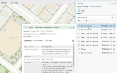
Our annual Spring Sale at Geospatial Training Services has begun! From April 25th - May 31st you can save 20% on any of our training events. This includes in-person and live-online training along with all our self-paced training. Self-paced training includes our...
Articles & Tutorials
Visualizing California Wildfire Activity with R
From 2011 to 2020, there was an average of 62,805 wildfires annually and an average of 7.5 million acres impacted annually. In 2020, 58,950 wildfires burned 10.1 million acres, the second-most acreage impacted in a year since 1960; nearly 40% of these acres were in...
Tutorial: Sorting Data by Area with ArcGIS Pro
In this tutorial, you’ll learn how to calculate the area of a polygon dataset and sort the results. If you have a set of polygons, you can use easily calculate and add the area of each polygon to its attribute table. This is what we’ll do in this tutorial for a set of...
Leaving Los Angeles Flow Map
Flow maps, like the one you see below, provide a great way of visualizing the movement of variables between an origin and a destination. 2021 saw a 20% rise in movers for the year compared to 2020, with an estimated 56% of Americans moving in 2021 while just...
Creating Animated Maps with R
Animated maps, like the one you see below, provide a powerful enhancement to show how data evolves over time. In this tutorial you'll learn how to use R with the ggmap, tidyverse, and gganimate libraries to produce animated maps like you see below. This animated map...
Tutorial: Combining Multiple Datasets into a New Dataset with ArcGIS Pro
In this tutorial, you’ll learn how to combine multiple datasets into a new one using the Merge tool. In an earlier tutorial, you learned how to use the Append tool to add new data to an existing dataset. This would change the existing dataset, as new records would be...
Tutorial: Adding New Features to a Dataset with the Append Tool in ArcGIS Pro
In this tutorial, you’ll learn how to append new data to existing data in Pro using the Append tool. The Append Tool in ArcGIS Pro is used to add new features or other data from multiple datasets into an existing dataset. It adds new data to an existing dataset of the...
Tutorial: Creating a COVID-19 Map of NYC in ArcGIS Pro
In this tutorial, you’ll be recreating a COVID map of NYC that shows percentages of COVID cases for different parts of the city over the last seven days. Introduction The following link shows an interactive web map of COVID-19 cases in NYC (also displayed on the image...
Tutorial: Converting Shapefiles to JSON with ArcGIS Pro
In this tutorial, we’ll cover how you can do data conversion with ArcGIS Pro’s Conversion toolset. Data conversion means that you will change data from one file format to another. This is often required when importing or exporting data out of Pro and use it in another...
Tutorial: Introducing the Field Statistics to Table tool in ArcGIS Pro 2.9
In this tutorial, we’ll cover the Field Statistics to Table tool, that gives more flexibility to calculating field statistics from attribute table data. As the name suggests, the Field Statistics to Table tool creates a standalone table of descriptive statistics for...