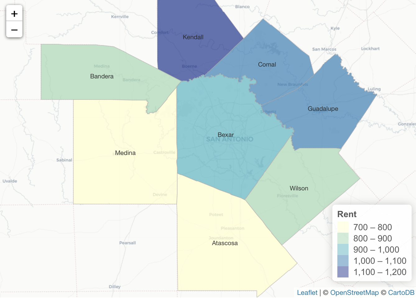
Articles & Tutorials

April Sale

April Sale

During the month of April you can save $100 on our upcoming live training classes.  This includes our live-online classes as well as many of our classroom events.  To take advantage of this offer, enter the discount code 'april' when checking out online.  This offer...

read more
How to Add Data Science to your GIS Skills

How to Add Data Science to your GIS Skills

GIS professionals interested in data science can start their journey into this field by exploring various spatial data analysist tools offered by ArcGIS and learning how to code. Current GIS software offers many tools that fall into the data science category. As such,...

read more
Why the Future Looks Bright for Data Scientists

Why the Future Looks Bright for Data Scientists

A recent study from job site Glassdoor showed that data scientist is currently the best job to apply for, offering a median base salary of $110,000 and job satisfaction of 4.4 out of 5. Let´s have a look at the different types of data scientists and the required...

read more
What’s New in ArcGIS Pro 2.1

What’s New in ArcGIS Pro 2.1

Esri has released ArcGIS Pro 2.1. This is a major release, and ArcGIS Pro 2.1 continues the trend of moving closer to parity with ArcMap and ArcCatalog as far as available tools and functionality. Because ArcGIS Pro is a native 64-bit application (ArcMap and...

read more
March Sale – Buy 1 Get 1 Free – ArcGIS Pro Classes

March Sale – Buy 1 Get 1 Free – ArcGIS Pro Classes

Our March sale is a "Buy 1 - Get 1 Free" on the self-paced version of our ArcGIS Pro classes.  When you buy Learning ArcGIS Pro 1: Fundamentals we'll also give you free access to our Introduction to Programming ArcGIS Pro with Python class or vice versa.  Self-paced...

read more
Glassdoor Ranks Data Scientist #1 Job in America

Glassdoor Ranks Data Scientist #1 Job in America

Glassdoor, one of the fastest growing job and recruiting sites, recently rated Data Scientist as the #1 job in America based on number of job openings, salary, and overall job satisfaction. Geospatial Training Services offers a number of classes to help you get up to...

read more
R Tutorials for Spatial Analysis

R Tutorials for Spatial Analysis

R has a full library of tools for working with spatial data. This includes tools for both vector and raster data, as well as interfacing with data from other sources (like ArcGIS) and making maps. Here are some excellent resources for learning R and R for Spatial...

read more

Categories

Recent Posts

Sign up for our weekly newsletter
to receive content like this in your email box.