Articles & Tutorials

What’s New in ArcGIS Pro 2.1

What’s New in ArcGIS Pro 2.1

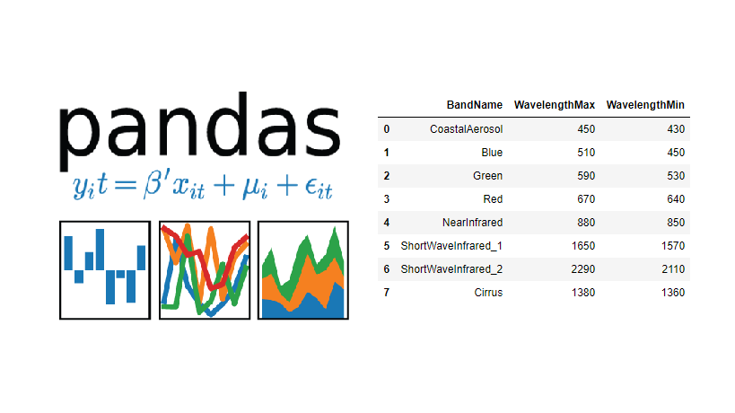
Esri has released ArcGIS Pro 2.1. This is a major release, and ArcGIS Pro 2.1 continues the trend of moving closer to parity with ArcMap and ArcCatalog as far as available tools and functionality. Because ArcGIS Pro is a native 64-bit application (ArcMap and...

read more
March Sale – Buy 1 Get 1 Free – ArcGIS Pro Classes

March Sale – Buy 1 Get 1 Free – ArcGIS Pro Classes

Our March sale is a "Buy 1 - Get 1 Free" on the self-paced version of our ArcGIS Pro classes.  When you buy Learning ArcGIS Pro 1: Fundamentals we'll also give you free access to our Introduction to Programming ArcGIS Pro with Python class or vice versa.  Self-paced...

read more
Glassdoor Ranks Data Scientist #1 Job in America

Glassdoor Ranks Data Scientist #1 Job in America

Glassdoor, one of the fastest growing job and recruiting sites, recently rated Data Scientist as the #1 job in America based on number of job openings, salary, and overall job satisfaction. Geospatial Training Services offers a number of classes to help you get up to...

read more
R Tutorials for Spatial Analysis

R Tutorials for Spatial Analysis

R has a full library of tools for working with spatial data. This includes tools for both vector and raster data, as well as interfacing with data from other sources (like ArcGIS) and making maps. Here are some excellent resources for learning R and R for Spatial...

read more
3 New Features of the ArcGIS API for Python

3 New Features of the ArcGIS API for Python

Late December of 2017, Esri released the 1.3 version of their ArcGIS API for Python. The release counts many new features and capabilities. Three of these are covered below: easier login to ArcGIS Online, a new module for data enrichment and an easier ways to save and...

read more
List of 150+ State GIS Servers with Open Data

List of 150+ State GIS Servers with Open Data

Today’s post comes to us from Joseph Elfelt from MappingSupport.com.  Last week Joseph presented his list of 50+ Federal GIS open servers.  Both these lists are great resources! Below is a link to a PDF I put together with a list of state ArcGIS servers with open...

read more
List of 50+ Federal GIS Servers with Open Data

List of 50+ Federal GIS Servers with Open Data

Today's post comes to us from Joseph Elfelt from MappingSupport.com. As a software developer in the field of online maps I am aware that the federal government operates various GIS servers with open data. Anyone with the right tech savvy can access that data. No login...

read more

Categories

Recent Posts

Sign up for our weekly newsletter
to receive content like this in your email box.