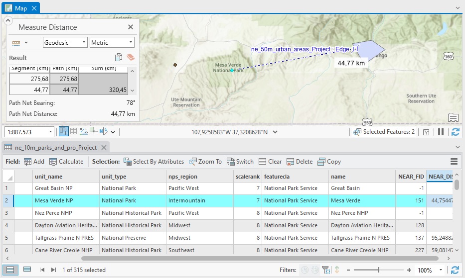
Articles & Tutorials

Tutorial: Creating A Spatially Enabled DataFrame in ArcGIS Pro

Tutorial: Creating A Spatially Enabled DataFrame in ArcGIS Pro

In this tutorial, we’ll show how you can use a Spatially Enabled DataFrame (SDEF) in ArcGIS Pro to easily convert feature classes back and forth to pandas dataframes. Esri’s ArcGIS API for Python introduced the Spatially Enabled DataFrame, an object to manipulate...

read more
Dynamic Feature Clustering in ArcGIS Pro 2.9

Dynamic Feature Clustering in ArcGIS Pro 2.9

The latest release of ArcGIS Pro includes a new way to aggregate features into clusters. This tutorial explains how to use this capability. What is feature clustering? Feature clustering is a way to aggregate point features into clusters, which are symbols that...

read more
Tutorial: Configure and Display Pop-ups in ArcGIS Pro

Tutorial: Configure and Display Pop-ups in ArcGIS Pro

In this tutorial, we’ll learn how to configure and display simple pop-ups for feature layers. In Pro, pop-ups can be configured to display information about individual map features. Rather than statically displaying this information on a map, the user can click on a...

read more
Tutorial – Creating a Heat Map in ArcGIS Pro

Tutorial – Creating a Heat Map in ArcGIS Pro

In this tutorial, you will learn how to create a heat map in ArcGIS Pro. This heat map will display the distribution of individual points that represent populated areas in the US. Using population values as a weight field, we can visualize the highest populated areas...

read more
Combining Multiple Spatial Analysis tools in ArcGIS Pro

Combining Multiple Spatial Analysis tools in ArcGIS Pro

The following tutorial uses multiple spatial analysis tools to be able to compare population counts for the four different regions in the US. When doing spatial analysis, you often must combine multiple tools to be able to find a solution to a specific problem. This...

read more
Tutorial: Mapping Migration Flows with R

Tutorial: Mapping Migration Flows with R

The American Community Survey Migration Flows dataset estimates the number of people that have moved between pairs of places. The estimates are calculated based on where a person lived when surveyed and where they lived one year prior to being surveyed. The data is...

read more
ArcGIS Pro 2.8’s New Copy Python Command

ArcGIS Pro 2.8’s New Copy Python Command

ArcGIS Pro 2.8 comes with a new handy feature that copies the Python command when running a geoprocessing tool inside Pro. This tutorial shows how the tool works, describes some best use cases and how the interpret the results. Pro 2.8 introduces a new handy feature...

read more
Mapping Population Growth Hot Spots with R and ArcGIS Pro

Mapping Population Growth Hot Spots with R and ArcGIS Pro

This tutorial demonstrates how to use R and ArcGIS Pro to generate hot spot maps of population growth by census tract. In a previous article I showed you how to use the tidycensus R package to quickly access and map US census data. You can also download a free copy of...

read more

Categories

Recent Posts

Sign up for our weekly newsletter
to receive content like this in your email box.