

Esri has just released a major version of ArcGIS Pro. We’ll have a look at some important new features below.
Version 3.0, released in June 2022, is a major update of Pro, which means new functionality, a new design and more. Here are some of the highlights of the new Pro release.
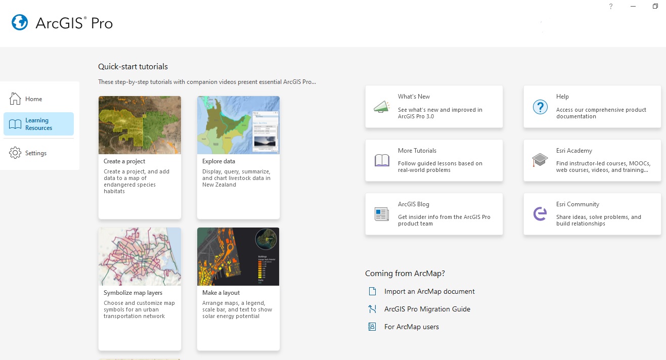
New Start Page
With a new redesign, Pro’s start page looks like a web interface containing a logical menu. Simplicity is key: on the left you see a small menu with three tabs (home, learning resources and settings). The Recent Projects menu now has a search bar to search for projects, or filter by name or date. You can also clear the entire list of projects or remove single projects manually. The new Learning Resources page also has a web interface look. It contains multiple tutorials and links to help new users get up to speed with using Pro and gives existing users new info on updates.
New Package Manager
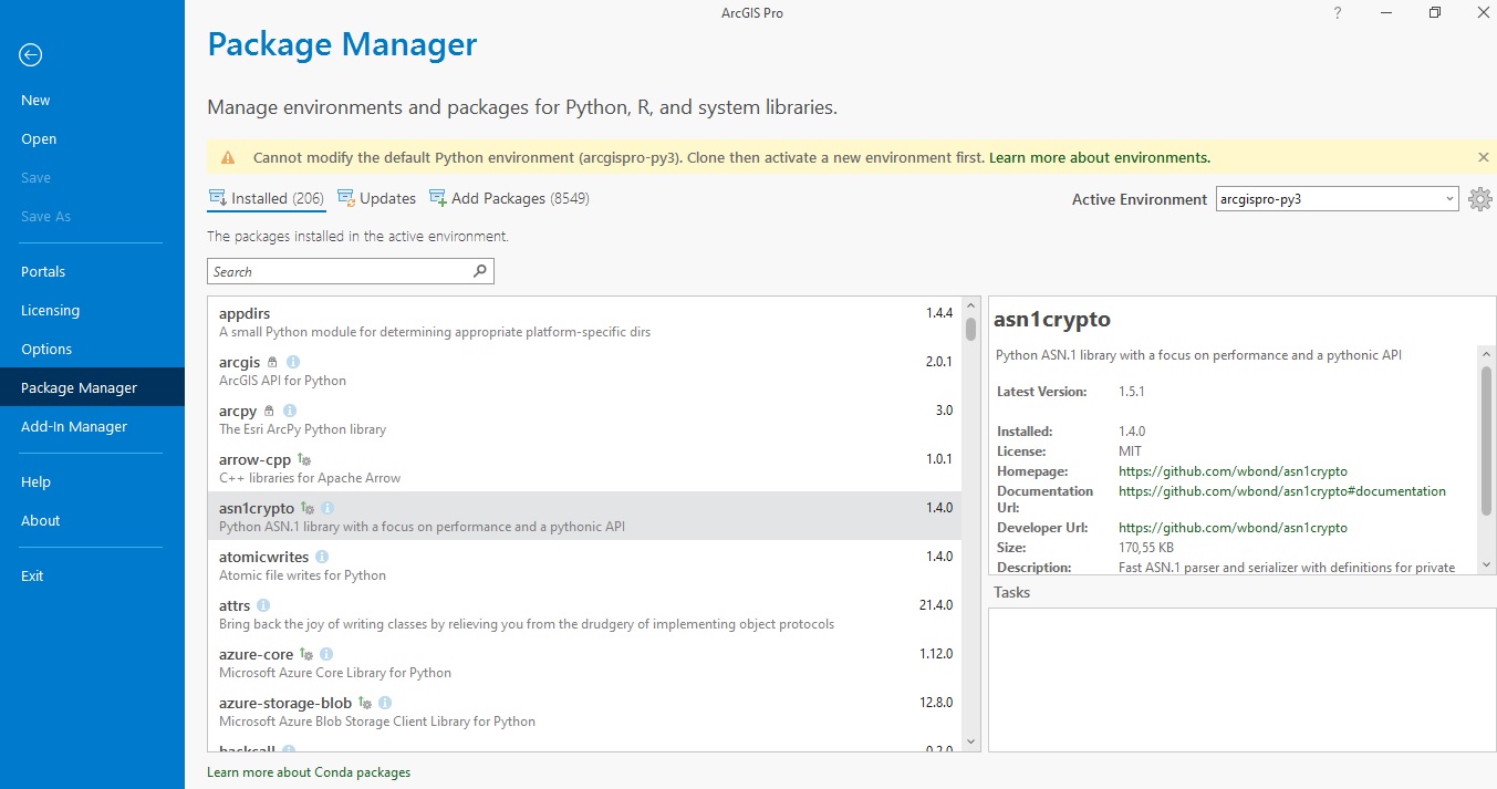
What was called the Python page in earlier Pro versions is now called ‘Package Manager’ and is the result of a collaboration between Esri and Anaconda announced earlier this year and uses conda for managing and installing Python and R packages. The Package Manager page lets you manage environments and packages for Python, R, and system libraries. Anaconda users will recognize that this looks like Conda, which is Anaconda’s package and virtual environment manager. This page is accessed by clicking ‘Settings’ on the start page and then ‘Package Manager’.
The package manager in Pro is Python 3.9 compatible and shows which active environment has been selected, in the image below a default called arcgispro-py3 that comes with a new Pro install. This environment contains 206 Python packages and can be cloned (copied) and activated if necessary. The package manager screen also shows the name, version, and description for each Python package and on the right extra info such as the homepage and documentation URL for each installed package. Many installed packages come with a tooltip (with the letter ‘I’), that shows a longer description. The Updates button shows you which installed packages are selectable for an update, and you can add packages to your environment of choice with the Add Package button (there are more than 8,500 packages available for installation).
Python Notebooks
There are only a few small and insignificant updates on Python Notebooks. Unfortunately, there is still no option to name a notebook or reopen it if you accidentally close it other than using the Catalog window. The notebooks would also benefit massively from having an undo button if you happen to delete a cell with code or lose/delete code.
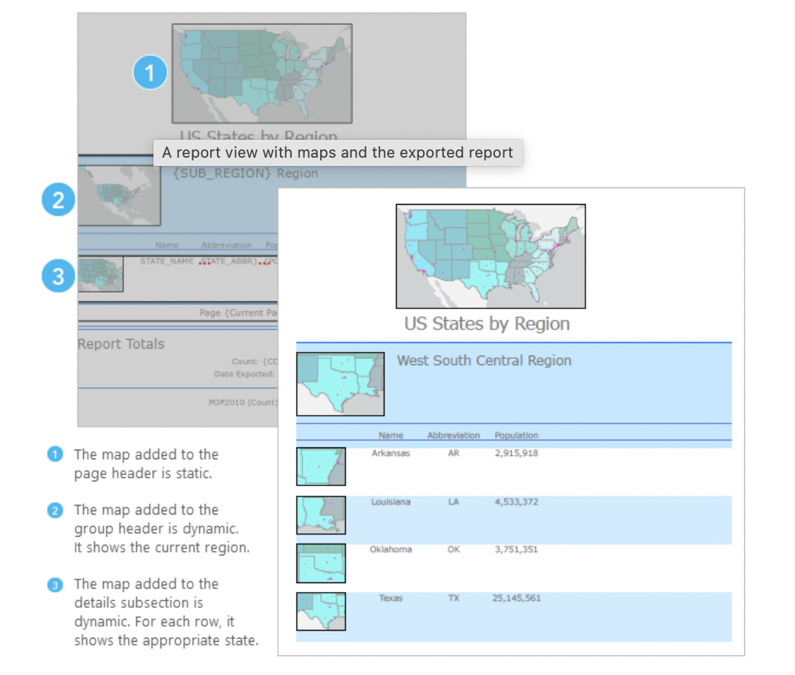
Add Maps to Reports
You can now add a map to a report. Maps that you add to the report header or footer are static. You can activate the map frame to adjust the map extent or scale. Maps that you add to a group header, group footer, or details subsection are dynamic. In the report view, the map frame of a dynamic map cannot be activated; however, the exported result updates in scale and extent to reflect the feature or features included in that subsection.
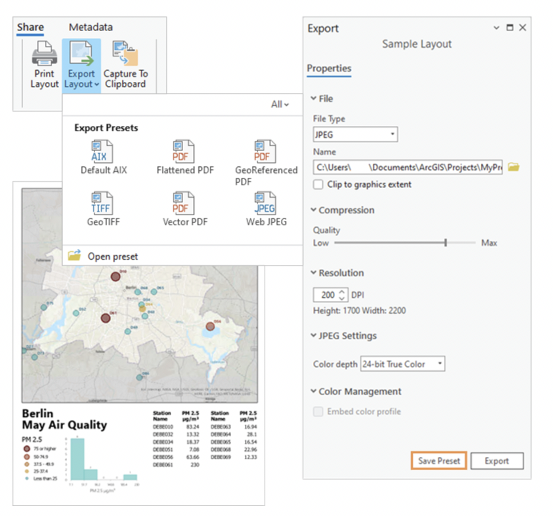
Export Presets
You can create export presets for maps and layouts in ArcGIS Pro. Export presets save all the settings for a particular export type. When you export a map or layout, you can select a default preset or a custom preset you created. This allows for a faster and more consistent export experience.
Presets are available in the export gallery on the Share tab of the ribbon. You can also browse to preset files (.xprt) on the file system. Presets can be created for any export type.
Performance and Productivity
Performance
- Pictures in layouts, reports, map graphics, and symbols are now stored as binary references. This can reduce project size and increase opening speed for projects with many duplicate images.
- Creating point scene layer packages is substantially faster.
- Creating building scene layer packages is substantially faster with parallel processing.
- Cache data access speed has been improved so that previously cached features now draw faster.
- When you export a map or layout to PDF format, vector content is clipped beyond map frame boundaries to create smaller export files.
- JPEG2000 compression is supported for images in PDF export.
Productivity
- Geoprocessing tools with feature layer or table view inputs show a message indicating how many records will be processed when a selection or filter is applied.
- Certain tools that you open from the ribbon, toolbars, and other locations automatically populate tool parameters with previously used values.
- The Export Features and Export Table geoprocessing tools give you control over the field order, field data type, and row order of output datasets.
- You can open a project item’s system folder with the Show In File Explorer context menu command.
- You can open ArcGIS Server Manager from an ArcGIS Server connection in a project.
- You can copy an item’s path using a context menu command or the keyboard shortcut Ctrl+Alt+P.
- You can copy and move folders and project items using context menu commands or drag and drop.
- You can estimate credit consumption before running the Geocode Addresses and Reverse Geocode tools when the active portal is ArcGIS Online and the input locator is the ArcGIS World Geocoding Service.
Installation process
Installing ArcGIS Pro 3.0 requires .NET 6 Desktop Runtime x64. You need to install this first before downloading and updating to Pro 3.0.
Migrating from ArcGIS Pro 2.x to 3.0
Migrating to Pro 3.0 from a 2.x version may break or change existing workflows. For example, add-ins created on 2.x versions have to be rebuilt, and reading Excel .xlsx files is no longer supported with the Python xlrd library. With Pro 3.0, this should happen with either the pandas or openpyxl library. These and other things can be found in a handy overview available here.
Learn More about ArcGIS Pro
Want to learn more about ArcGIS Pro? We have an extensive list of ArcGIS Pro classes that will take you from beginner to advanced user. Not sure where to begin? Our Learning Pathways document can guide you in the process of selecting classes in an appropriate order.
