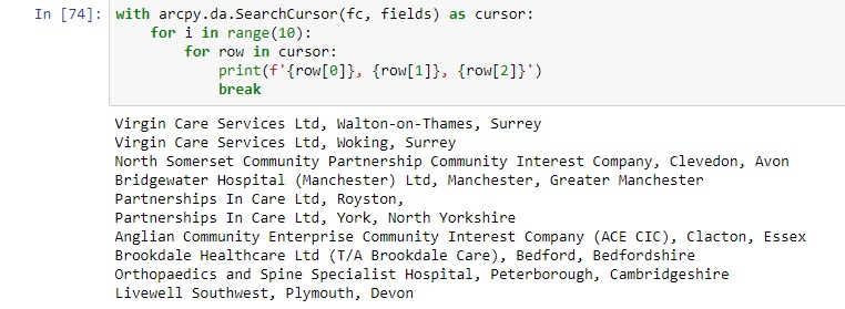
This year’s Esri User Conference plenary sessions featured a presentation showing how an insurance company in San Antonio, Texas uses ArcGIS Pro to train neural deep learning networks, in order to automate and speed up damage assessment and building footprint...
Articles & Tutorials
New Book Coming Soon – Exploring and Visualizing US Census Data with R
This November (2019) my new book – Exploring and Visualizing US Census Data with R will be published. You can get a free copy of the digital version of this book simply by entering your email address. The book will be delivered to your email inbox no later than...
ArcGIS Pro Keyboard Shortcut List
When teaching ArcGIS Pro classes, I am often asked about keyboard shortcuts. They are not all the same as ArcMap. Here is a link for a PDF poster from Esri showing the keyboard shortcuts for ArcGIS Pro. Hope this is helpful....
Esri User Conference Product Updates
Together with this year’s Esri UC, a set of product updates were announced: ArcGIS Pro 2.4, its product extensions, the Pro .NET SDK and the ArcGIS API for JavaScript. ArcGIS Pro 2.4 The most important product release for this year’s UC is the latest release of ArcGIS...
A Computer Nerds Guide to Hardware for ArcGIS Pro
I know most of us in the GIS field do not pay a lot of attention to basic computer tech such as processors or video cards. However with the migration to ArcGIS Pro, the need to be up to date on current computer tech trends is increasing. As a closet (ok not so closet)...
ArcGIS Pro 2.4 is Here. So What’s New?
Esri has released a new version of ArcGIS Pro, 2.4. This new version does contain many great enhancements and new functionality which I am very excited about. I think you will be as well. Here is a list of what I feel are some of the key improvements in this...
Map Annotation and Graphics coming to ArcGIS Pro in the Future
I am very excited to tell you Esri’s Dev Team has decided to reverse their stance on not supporting map annotation and graphics in ArcGIS Pro. Originally it had been posted that there was no intention to support this functionality in ArcGIS Pro. I had been told this...
Exporting Census Data to Shapefiles with R
In a previous article you were introduced to using US Census data using the tidycensus R package. In that article you learned how easy it is to generate R datasets containing either decennial or American Community Survey (ACS) data and visualize that information as...
The Many Applications of GIS
Click to Enlarge Image
Building Scene Layers in ArcGIS Pro 2.3
With the release of ArcGIS Pro 2.3, Esri has introduced yet another 3D building content format that is targeted at the Architecture, Engineering, and Construction (AEC) market, in order to realize better GIS and BIM integration. What is a Building Scene Layer? Esri’s...