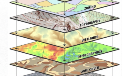
Read Part 1 Read Part 2 Part 3: Geodatabase Data Models and Schema Design Effective geodatabase schema design is fundamental to creating robust, efficient, and maintainable spatial data systems. The geodatabase data model provides sophisticated tools for organizing...
Articles & Tutorials
Understanding the Geodatabase Format – Part 2
Part 2 of a 6 part series on the geodatabase data format. You can read Part 1 here. The geodatabase architecture in ArcGIS Pro encompasses three distinct implementation types, each designed to serve specific use cases and deployment scenarios. Understanding the...
Understanding the Add Data Widget in Experience Builder: Benefits and Limitations
For upcoming Experience Builder courses, view our training schedule: GIS Training – Geospatial Training Services The Add Data widget in ArcGIS Experience Builder offers a simple way to allow users to dynamically bring additional data into a web application. Rather...
Exporting Data from Experience Builder: How to Properly Configure Hosted Feature Layers in ArcGIS Online
For upcoming Experience Builder courses, view our training schedule: GIS Training - Geospatial Training Services In many public-facing Experience Builder applications, providing users the ability to export data is a useful feature, whether for transparency,...
Understanding the Geodatabase Format in ArcGIS Pro – Part 1
Part 1 of a 6 part series on the geodatabase data format. Foundation and Core Concepts The geodatabase is the cornerstone of data management in ArcGIS Pro, representing Esri's flagship format for storing, managing, and analyzing geographic information. Unlike simple...
What’s New with Data Actions in Experience Builder
Since our last article on configuring data actions in Experience Builder, Esri has added several new data actions and expanded existing ones, providing even more functionality for end-users. This quick guide highlights what’s new and how you can use these capabilities...
ArcGIS Online Security Settings You Could be Overlooking
Introduction: Why Security in ArcGIS Online Matters ArcGIS Online (AGO) is a powerful cloud-based platform for managing and sharing GIS data, maps, and applications. While its ease of use and collaborative features make it popular among organizations, it also comes...
ArcGIS Pro 3.5: Enhanced Performance and Intelligence for Modern GIS Workflows
Learn more about ArcGIS Pro in our introductory Mastering ArcGIS Pro 3: Maps, Layers, Projects, and Layouts class and our intermediate level Mastering ArcGIS Pro: Editing, Analysis, and Automation class. The May 2025 release of ArcGIS Pro 3.5 delivers significant...
Understanding GIS Data Formats in ArcGIS Pro: A Comprehensive Guide
GIS data comes in many shapes and formats, and ArcGIS Pro supports a wide variety of data formats that can be used as sources for layers in your mapping projects. While ArcGIS Pro works with numerous formats, geodatabases represent the cornerstone of efficient data...
Tips and Tricks for Creating Adjacent Polygons Without Gaps or Overlaps in ArcGIS Pro
Save 20% on our GIS training through May 31st by using the discount code springsale when checking out. Why Topological Accuracy Matters In GIS, adjacent polygons must meet seamlessly to support reliable spatial analysis. Gaps or overlaps between features can lead to...