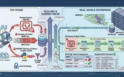
Articles & Tutorials

Introducing Location3x: GIS Services and Solutions

Introducing Location3x: GIS Services and Solutions

Introduction to Location3x We're excited to announce the launch of Location3x—a new division of Geospatial Training Services dedicated to helping government agencies get more from their GIS investments. For nearly two decades, we've trained over 14,000 GIS...

read more
Choosing the Right Projection for COGO Work in ArcGIS Pro

Choosing the Right Projection for COGO Work in ArcGIS Pro

When using Coordinate Geometry (COGO) tools in ArcGIS Pro, projection choice influences how distances and bearings are interpreted, where linework is placed, and how boundary areas are calculated. Because projections define how the curved surface of the earth is...

read more
Ground-to-Grid in ArcGIS Pro: What It Means for COGO Editing

Ground-to-Grid in ArcGIS Pro: What It Means for COGO Editing

When working with Coordinate Geometry (COGO) in ArcGIS Pro, it helps to separate two ideas that sound similar but behave differently: ground measurements and grid measurements. Survey and engineering documents often describe distances “on the ground,” while GIS stores...

read more

Categories

Recent Posts

Sign up for our weekly newsletter
to receive content like this in your email box.