
Ask three GIS professionals how they automate work in ArcGIS Pro and you’ll often get three different answers, each delivered with the conviction that theirs is the “real” way to do it. The Python crowd treats everything else as training wheels. The ModelBuilder users point out, fairly, that they get repeatable analysis done without writing a line of code. And a quieter third group leans on the Task Framework to keep a team of editors doing the same job the same way every single time.
Here’s the thing: they’re not actually arguing about the same problem. ArcGIS Pro ships with three distinct automation tools, and the reason “which one is best” never gets settled is that it’s the wrong question. These tools aren’t competitors. They answer three different questions:
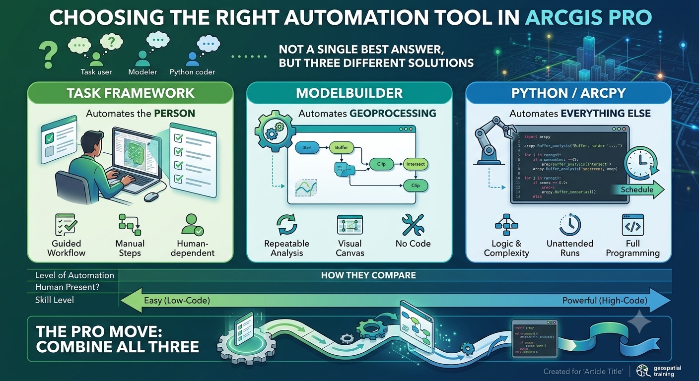
- The Task Framework automates the person — it makes sure a human performs a multi-step interactive workflow correctly and consistently.
- ModelBuilder automates the geoprocessing — it chains tools into a repeatable analysis without requiring code.
- Python/ArcPy automates everything else — including logic no geoprocessing tool can express, and jobs that need to run with nobody at the keyboard.
Once you frame the choice that way, “which is appropriate” mostly answers itself. Let’s walk through each, then look at how to decide — and, most importantly, how experienced shops combine all three.
The three tools at a glance
The Task Framework lets you build a task: a set of preconfigured steps that guide you or a colleague through a workflow or business process. You author tasks in the Task Designer, with no code involved, and each step can be set to run manually (the user clicks Run), run automatically, or be optional or hidden. A step can launch a specific tool — the Create Features pane, a selection tool, a geoprocessing tool — position the map, and set which layers are visible, selectable, and editable before the user acts. Finished tasks live inside the project but can be exported to a standalone .esriTasks file and imported into other projects, which is how you distribute a standardized workflow across a team.
ModelBuilder is a visual programming environment for geoprocessing. You drag tools onto a canvas and connect them so the output of one becomes the input of the next, building a repeatable analytical workflow without writing code. Models support iterators for looping over datasets and preconditions for basic branching, and a finished model becomes a tool you can run, share, or publish.
Python/ArcPy is the full programming option. ArcPy exposes essentially every geoprocessing tool to Python, but the real advantage is everything around the tools: loops, conditional logic, exception handling, file and database access, and integration with the broader Python ecosystem. A Python script can run inside ArcGIS Pro, run as a custom script tool or Python toolbox (.pyt), or run entirely on its own — on a schedule, on a server, on a disconnected machine.
How they compare

The pattern to notice: as you move from left to right, you trade ease of authoring for power and unattended capability. The Task Framework is the easiest to build and the most dependent on a human; Python is the hardest to build and the most independent. ModelBuilder sits in the middle, which is exactly why it’s such a useful tool to grow into.
Which tool for which task
Reach for the Task Framework when the bottleneck is people, not processing
The Task Framework shines when the work itself isn’t complicated — it’s the consistency that’s hard. If four editors each maintain parcels a slightly different way, the problem isn’t geoprocessing horsepower; it’s that step six gets skipped, attributes get entered out of order, and QC depends on who happens to be doing the work.
Good candidates:
- Standardized editing workflows. Parcel maintenance, address point creation, road centerline editing — anything where the sequence and the mandatory attribute entry matter. In fact, Esri ships predefined task files for exactly this kind of work, including parcel fabric editing and administration, which you can import and adapt to your own data.
- Onboarding and training. A task walks a new hire through a procedure step by step, with instructions and tooltips at each stage, so they can’t accidentally skip a required step. Your standard operating procedure stops living in a Word document nobody reads and starts living in the software where the work actually happens.
- Multi-step interactive processes where correctness beats speed. If the goal is “everyone does this the same defensible way,” a task captures that institutional knowledge better than any written guide.
The Task Framework is the right answer surprisingly often, precisely because so much of the inconsistency in a GIS shop comes from people, not tools.
Want to build tasks for your own team? Geoprocessing Automation in ArcGIS Pro with Tasks walks through authoring and distributing tasks step by step, and Editing Data in ArcGIS Pro covers the editing workflows tasks are so often built around.
Reach for ModelBuilder when you’re chaining geoprocessing and want it visual
ModelBuilder is the natural fit when your work is a sequence of geoprocessing tools you run again and again, and you’d rather see and document that sequence than maintain code.
Good candidates:
- Recurring analysis. A suitability model that reclassifies inputs, weights them, and overlays the results. A public-notification workflow that buffers a rezoning parcel, selects everything within the notification distance, and exports the affected owners. Build it once, rerun it whenever the inputs change.
- Batch processing across similar inputs. Iterators let you run the same workflow over every feature class in a workspace or every county in a dataset without rebuilding the model each time.
- The on-ramp for analysts who think in tools but don’t yet code. This is one of ModelBuilder’s quiet strengths. The model diagram doubles as documentation that stakeholders and reviewers can actually follow — something a wall of Python rarely achieves.
ModelBuilder does support preconditions for simple branching, but be honest with yourself about where its limits are. Once your “if this, then that” logic gets complicated, or you need real error handling, you’ve outgrown the canvas.
New to building models? Introduction to ModelBuilder for ArcGIS Pro covers iterators, parameters, and sharing your models, and Introduction to GIS Analysis in ArcGIS Pro grounds you in the geoprocessing workflows worth automating in the first place.
Reach for Python when the job is big, conditional, scheduled, or talks to the outside world
Python is the answer when the work exceeds what a guided human session or a visual model can comfortably handle.
Good candidates:
- Unattended and scheduled jobs. A nightly ETL routine that pulls data, processes it, and republishes it — running at 2 a.m. with no one watching. ArcGIS Pro can schedule a model or geoprocessing tool directly from the Run menu, which handles simpler recurring jobs well. But that scheduler runs under your account and requires you to stay signed in to the machine. For serious ETL — especially when the job needs branching logic, logging, notifications, or integration outside ArcGIS — a standalone script run through Windows Task Scheduler is the more dependable choice, because it doesn’t depend on ArcGIS Pro being open or a user staying logged in.
- Large-scale batch work. Reprojecting hundreds of feature classes, repairing broken data sources across a project, or applying a fix to every dataset in an enterprise geodatabase. The kind of job where opening each item by hand is a non-starter.
- Integration with non-Esri systems. Reading from a REST API, querying a SQL database directly, pulling Census ACS tables, or handing data off to pandas for analysis. ArcPy plus the wider Python ecosystem reaches well beyond the geoprocessing toolbox.
- Robust, defensible automation. When you need real exception handling, logging, and notifications — automation a colleague can trust to either succeed or tell you exactly why it failed.
- A clean interface over messy logic. Wrap complex code in a custom script tool or Python toolbox (
.pyt) and you give non-coders a simple dialog box on top of sophisticated logic underneath.
The cost, of course, is that Python is genuine programming. It carries a steeper learning curve and a real maintenance burden. But for anything that has to scale, branch, or run on its own, it’s the only one of the three that gets you there.
Ready to start writing code? Introduction to Programming ArcGIS Pro 3.x with Python is the place to begin, Data Analysis with ArcGIS Pro 3.x and Python takes you further into real analytical workflows, and Automating ArcGIS Pro Tasks using AI Generated Python Code shows how to put AI to work writing the automation for you.
The move that separates the pros: combine them
The most common mistake isn’t picking the wrong tool — it’s assuming you have to pick only one. Experienced shops layer all three, letting each do what it does best.
- A Task whose steps launch models or scripts. The task guides the human through the workflow; behind individual steps, a model or script does the heavy lifting. You get both consistency and automation — the person is steered, the computation is handled.
- A model that graduates into a script. Prototype your analysis visually in ModelBuilder, then export it to Python as a starting scaffold. One caveat worth knowing: the export captures your tool sequence, but iterators and the model-only logic tools don’t carry over — you add the loops, the if/else branching, and the error handling yourself in Python. That’s not a flaw; it’s precisely the maturity path from low-code prototype to production-grade script.
- A tested script wrapped as a tool, embedded in a Task. Package a proven script as a script tool, then drop it into a task step so a non-coder can run sophisticated logic safely, without ever touching the code.
That progression is the real takeaway: guide the human, automate the geoprocessing, then productionize with Python. You don’t choose one tool for your whole career — you reach for the right one for the job in front of you, and you combine them as the work demands.
A few practical caveats
Before you commit to an approach, a few details that trip people up:
- ModelBuilder can be scheduled, but Python is still better for production-grade automation. ArcGIS Pro schedules models and tools from the Run menu, and behind the scenes it even generates a Python script to do the work. But scheduled runs happen under your user account and require you to stay signed in to the machine, so they aren’t a substitute for a true server-side or fully unattended process. For anything mission-critical, a standalone script gives you the control, logging, and independence that matter.
- Tasks are tied to their project context. A task references the maps, layers, commands, and tools in the project where it was built. When you share an
.esriTasksfile, those references can come up as validation errors if the destination project is missing a layer or tool. Open and validate a task in the new project — and fix any broken resources — before you hand it to your team. - Export-to-Python is a scaffold, not a finished product. It’s a great way to learn the syntax and get a head start, but treat the output as a draft you’ll refine, not a script you can run untouched.
Where to go from here
If you’re standardizing how a team works, start with the Task Framework. If you’re building repeatable analysis and prefer to see your workflow, start with ModelBuilder. And when you hit the ceiling on either — when you need scale, real logic, scheduling, or integration with the world outside ArcGIS — that’s your signal that it’s time to learn Python.
That last step is where most GIS professionals see the biggest return on their time, and it’s where the right training makes the difference between copying snippets you don’t fully understand and writing automation you can trust. Geospatial Training Services offers hands-on courses across all three tools, from Introduction to ModelBuilder for ArcGIS Pro and Geoprocessing Automation in ArcGIS Pro with Tasks to Introduction to Programming ArcGIS Pro 3.x with Python.
For teams, the Annual GIS Training License provides 24/7 access to the full self-paced catalog, so everyone can grow into the right tool for the job.
