

Survey123 is a magical application that allows you to create input forms that can be used on the web or from mobile devices. They can be used online, or offline. These survey forms can focus on community input, asset inventories, stakeholder feedback, and more. So, when it comes to designing your survey form, there are some factors you need to consider, with data management being one of the most important. This is where Survey123 Input Masks can help.
Because data management is one of the most important things you do as a GIS professional, standardizing the way users input data into your forms can help streamline your QA/QC process. This provides ready-to-use data that doesn’t need to be scrubbed and reformatted on the back end.
What are Input Masks and Why should I use them?
Long gone are the days when you receive an incomplete and unusable response to a survey form question. An Input Mask defines the format required for a text string question. When an input mask is defined, responses to the question are forced to comply. This provides a standard data format which improves the quality of data received. It also helps you understand the data more quickly because you are not forced to interpret all the various ways respondents formatted their input text. This means you can utilize and summarize the values provided in the data more quickly and efficiently.
Input Mask Examples
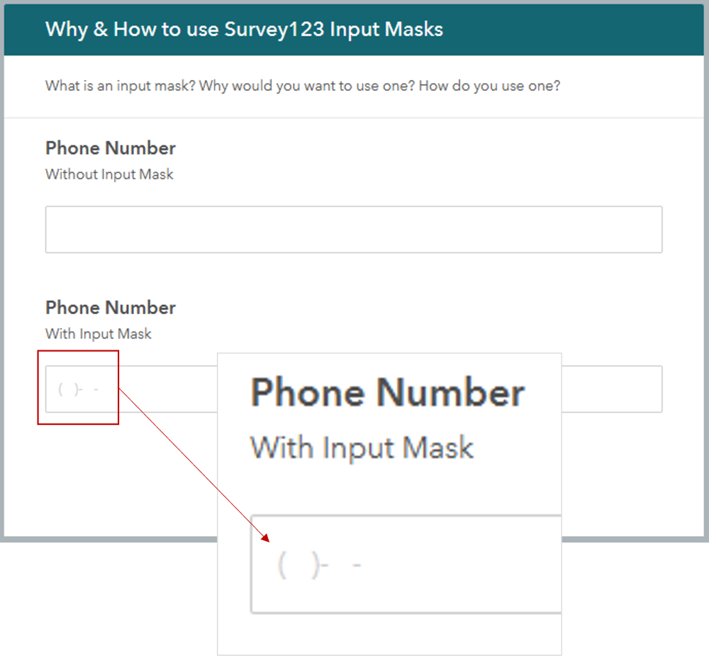
To put this into context, view the image at the top of this post. The first phone number entered into the form does not have an input mask defined. As you can see, the respondent included multiple symbols and spaces, and not enough numbers for a proper phone number. This entry would require a follow-up to the respondent, or it could remain incomplete or be deleted.
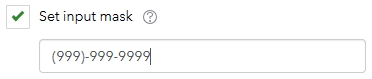
The phone number input mask is below. The number “9” means there is a required number between 0 and 9. Parentheses and dashes are automatically added by the survey form (second image below).
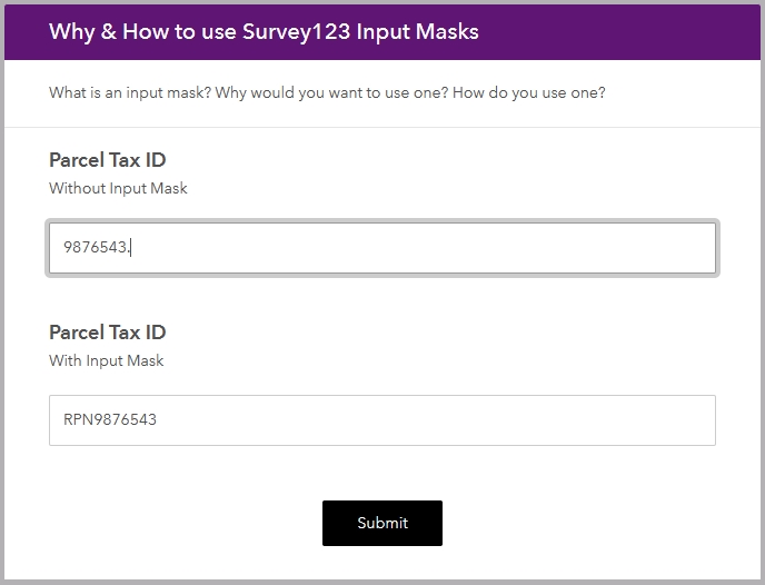
The below image is another example demonstrating the importance of Survey123 Input Masks. In the first response, the user did not include the preceding letters for the parcel tax ID. A period was also entered at the end of the number. These types of errors contribute to a data clean-up nightmare on the back end. The second response shows the correct parcel tax ID which includes 3 capital letters followed by 7 numbers.
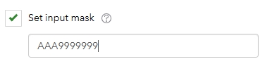
The input mask for the Parcel Tax ID is below. The “A” means there is a required capital letter, while the “9” is a required number between 0 and 9.
How do I define a Survey123 Input Mask?
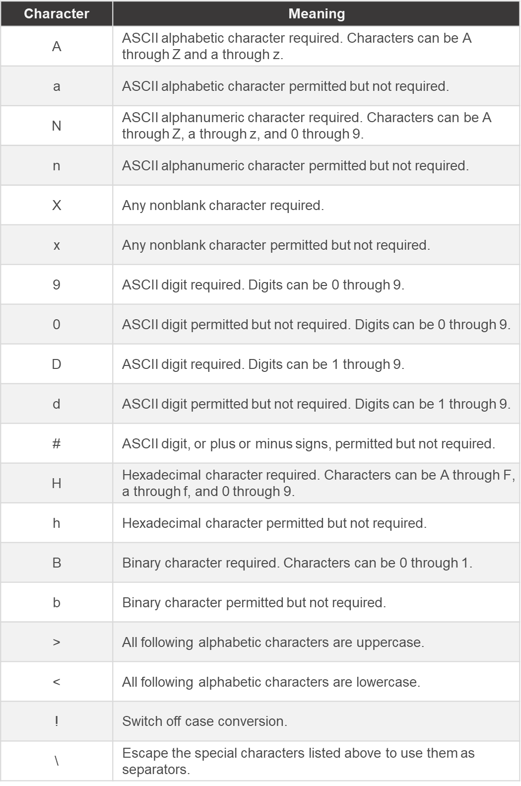
You will need to understand the characters and symbols that are used to define the format and layout for input masks. The below table provides a list of characters and their meaning. As you can see, some of the characters mean a value is required, while others represent a possible value entry.
The options for Survey123 Input Mask formatting are endless, but the only characters allowed at this time are listed above. If you find yourself struggling to come up with an input mask, here are a few more resources you can use:
If you would like to learn more about using Survey123 and Survey123 Connect, check out our Survey123 training details and schedule!
To receive tutorials and articles as they are published, subscribe to our newsletter.
