

For upcoming Experience Builder courses, view our training schedule: GIS Training – Geospatial Training Services
In many public-facing Experience Builder applications, providing users the ability to export data is a useful feature, whether for transparency, collaboration, or self-service data access. However, enabling data export requires more than simply adding a table widget. Several key settings in ArcGIS Online and Experience Builder must be properly configured to allow data export functionality. This article provides a step-by-step overview for hosted feature layers.
1. Enable Export on Hosted Feature Layer in ArcGIS Online
The first configuration occurs at the hosted feature layer item level in ArcGIS Online. Without the correct settings here, Experience Builder will not be able to export data regardless of widget configuration.
-
Enable Export Data:
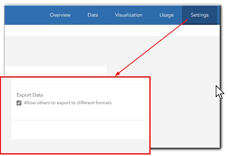
Navigate to the hosted feature layer item > Settings tab > Export Data section. Ensure that Allow others to export to different formats is enabled.-
This setting controls whether users can export the feature layer content to CSV, Shapefile, GeoJSON, or File Geodatabase.
-
If this box is not checked, Experience Builder widgets will not expose export functionality even if configured to allow it.
-
-
View Layers (if applicable):
If you’re using hosted feature layer views, confirm that export permissions are enabled on the view itself, not just on the source layer. Each view layer maintains its own export setting.
2. Configuring Export in Experience Builder
In addition to enabling export at the hosted feature layer item level, Experience Builder itself must be configured to allow export from the selected data sources.
-
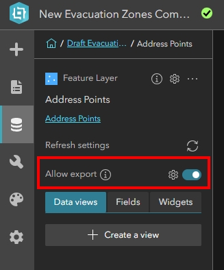
Enable Export from the Data Panel:
In Experience Builder, open the Data panel (left side of the builder interface). Locate the hosted feature layer data source you’ve added to your application.-
Toggle on the Enable export option for that data source.
-
This enables export capabilities for any widgets referencing this data source that support export functionality.
-
-
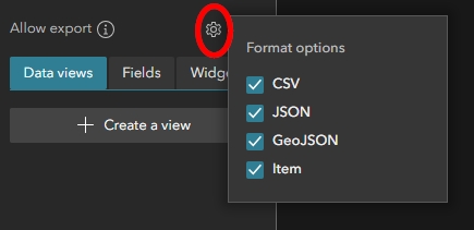
Export Format Options:
After enabling export, click the gear icon (settings) next to the data source to configure which export formats are available to the end user. Options typically include:-
CSV
-
JSON
-
GeoJSON
-
Feature Collection (depending on data type and widget compatibility)
-
-
Widget Behavior:
Once export is enabled at the data source level, compatible widgets such as Table, Query, List, or others may expose export tools automatically if their individual configurations allow it.
Widget-Level Data Actions:
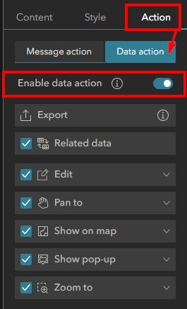
Export is exposed to users through widgets that support Data Actions, such as Query, List, or Feature Info widgets.
-
In the widget configuration, navigate to the Action tab and enable the Data Actions option.
-
Ensure the Export action is toggled on. You will see that you cannot toggle export on and off from the Data Action panel, but that the function is associated with Data Actions.
-
When properly configured, users interacting with the widget will see the Export option in the widget’s context menu.
Note: If export is not enabled in the Data panel, Experience Builder will not allow users to export data even if AGO item settings permit it.
3. Key Considerations
-
Attachment Export:
Experience Builder’s Table widget does not currently support exporting attachments directly. Export functionality is limited to attribute data. -
Record Limits:
Hosted feature layers in ArcGIS Online have record limits (max record count) that may restrict how many records load into Experience Builder, which in turn affects export results. -
Performance:
Exporting very large datasets from public-facing apps may impact performance. Consider limiting export to filtered subsets where practical.
Summary
By correctly configuring both ArcGIS Online item settings and Experience Builder widget options, you can provide reliable export functionality to your users while maintaining appropriate control over your data. To learn more about our Introductory and Intermediate Experience Builder courses, view our course catalog: GIS Training Courses – Full Catalog – Geospatial Training Services
