HOW TO ENSURE DATA QUALITY
High-quality data allows organizations to make better business decisions. One of the foundations of being a GIS Professional is data creation and management. We learn early in our education and careers that data management is one of the most important things we will do, because it is our data that feeds all of our models, analyses, visualizations, and maps. Poor data quality means poor GIS solutions which lead to poor decision-making.
So, what are some of the ways we can ensure quality data? Here is a short-list of things you can implement to help you maintain data quality:
- Invest in internal training for anyone who creates and edits data.
- Implement a single, authoritative source for each dataset.
- Establish a data auditing process that looks for erroneous data, blank data fields, and inconsistent formatting.
- Consider using choice-lists, or domains, to prevent users from misspelling words or entering erroneous data.
WHAT IS A DOMAIN CHOICE-LIST?
For this short tutorial, we want to focus on choice lists for data entry. Choice lists are defined by the domain of an attribute within a database. Basically, a domain is a unique set of values that can be assigned to an attribute. For example, an attribute field defined by the data type ‘STRING’ will only allow text string values to be entered, while a domain defined by a choice list of values will only allow those values to be chosen for entry.
Choice lists are beneficial because they simplify the data-entry process for users by allowing the user to choose from a drop-down list instead of manually typing in a response. This can help cut down on erroneous data in the form of misspelled words, inconsistent formatting, incorrect text, or additional spaces. Each of these examples can lead to inaccurate data analysis and representation.
HOW TO CREATE A DOMAIN CHOICE-LIST IN ARCGIS PRO
To create a domain choice-list in ArcGIS Pro, you first need to have your data stored in a geodatabase. A choice-list cannot be created on a flat shapefile. Once your feature layer is inside of a geodatabase, you will follow the below steps:
- Right-click on the geodatabase and choose “Domains” from the menu that appears.
- Fill out the Name and Description for your domain and include the field type (at a minimum).
- Create your coded domain choice list by added a code and description for that code; this is what is referred to as a coded value domain.
- Once it’s created and saved, you can assign the domain to an attribute from the fields view of your feature layer.

HOW TO CREATE A DOMAIN CHOICE-LIST IN ARCGIS ONLINE
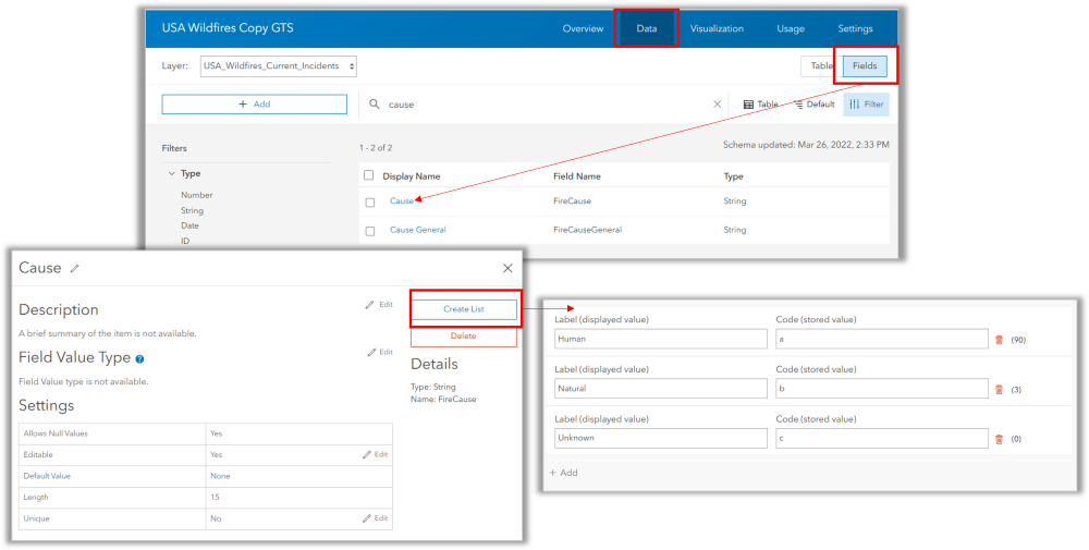
The process to create a domain choice-list in ArcGIS Online is much simpler:
- From the Data view of your hosted feature service, click on ‘Fields’ in the upper right to view the list of fields associated with the service.
- Click directly on the Display Name of the field you want to add a choice list to.
- When the field’s details appear, click on “Create List’ in the upper right.
- Add your labels (displayed values) and codes (stored values).

It is important to understand that you do not have to use simple codes if you do not wish to. You can use the categorical name as both the label and the code if that will be easier for data management and communication.

TO SUMMARIZE
Domain choice-lists are easy to create and will simplify the processes of data editing and collection. Using choice lists will increase data accuracy which can have a direct, positive impact on data analysis and decision-making.

