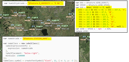
Articles & Tutorials

Free Chapter – Programming ArcGIS with Python Cookbook

Free Chapter – Programming ArcGIS with Python Cookbook

This Friday, July 31st my new book Programming ArcGIS with Python Cookbook (2nd Edition) will be published by Packt Publishing.  You can download and read a free chapter from the book.  This is Chapter 7: Querying and Selecting Data. We also have several classes...

read more
Dealing with Lots and Lots of Point Data in a Web Application

Dealing with Lots and Lots of Point Data in a Web Application

I recently had a fun question from a student on the Building Custom ArcGIS Server Applications with JavaScript class. He has a busy map service with in excess of 50,000 points on it, and was after some advice as to how to improve performance in a web application he...

read more
Understanding the ArcGIS Server Proxy Page and CORS

Understanding the ArcGIS Server Proxy Page and CORS

One thing that appears to cause more confusion than anything else among beginner users of the ArcGIS Server API for JavaScript is the use of the proxy page and CORS. Let's see if we can clear up that confusion once and for all. Before we get into the actual mechanics...

read more

10 Common Python Errors of Beginning ArcGIS Programmers

Over the years I have taught hundreds of beginning level Python programmers how to automate their ArcGIS geoprocessing tasks.   Needless to say I have seen all sorts of errors.  But there are some common errors that I see over and over again.  So if you're a beginner...

read more

CartoDB – Learn How to Import ESRI Shapefiles

Need to build a GIS website but don't know how to write code?  GeoSpatial Training Services is now offering a free self paced, web based course covering CartoDB.  Building GIS Web Sites without Programming Using CartoDB is now available as a self-paced online class. A...

read more

Querying and Selecting Data in ArcGIS 10.1 with Python

Today I'm releasing a free sample chapter from my soon to be published book Programming ArcGIS 10.1 with Python Cookbook.  Selecting features from a geographic layer or rows from a standalone attribute table is one of the most common GIS operations.  Queries are...

read more

Categories

Recent Posts

Sign up for our weekly newsletter
to receive content like this in your email box.