

The efficiency and effectiveness of spatial data management is paramount to GIS professionals. ArcGIS Pro offers versatile and powerful features known as ‘packages’, designed to streamline the process of sharing and managing geographical data. This article delves into the concept of ArcGIS Pro packages, their types, and the advantages they offer to GIS professionals and enthusiasts alike.
We’ve created a YouTube video to go along with this article. Please be sure to like and subscribe to our channel!
What are ArcGIS Pro Packages?
Packages in ArcGIS Pro are single files that contain various types of geographic data and related items. These packages are designed for easy sharing and efficient distribution of maps, data, and other GIS resources. They encapsulate everything from maps and data to tool configurations, making it simpler to transfer information between different systems or users.
Types of Packages in ArcGIS Pro
ArcGIS Pro offers several types of packages, each tailored for specific needs:
- Map Packages (.mpkx): These contain map documents and the associated data. They are ideal for sharing maps with all the necessary geographic data included.
- Layer Packages (.lpkx): These encapsulate the data source and layer properties, such as symbology and labeling, for a particular layer.
- Project Packages (.ppkx): Containing an entire project – maps, layouts, data, toolboxes, and styles – these are the most comprehensive package type. They are perfect for archiving or sharing complete projects.
- Geoprocessing Packages (.gpkx): These packages contain geoprocessing models, scripts, and tools along with the data they use. They are essential for sharing workflows and analysis methods.
- Task Packages (.tpkx): Designed to include interactive guides for performing GIS tasks, these packages help in standardizing processes and training users.
Advantages of Using ArcGIS Pro Packages
- Efficient Data Sharing: Packages simplify the process of sharing complex GIS data and resources. Instead of dealing with multiple files and ensuring all dependencies are included, users can share a single package file.
- Data Integrity and Security: When data and resources are packaged, it reduces the risk of file corruption or loss during transfer. Additionally, packages can be encrypted for added security.
- Ease of Collaboration: Packages facilitate smoother collaboration between team members, departments, or different organizations, ensuring everyone is working with the same data and resources.
- Simplified Project Management: The use of project packages helps in efficiently managing large and complex GIS projects, as all components are contained within a single file.
- Streamlined Workflows: Geoprocessing and task packages enable the standardization of workflows, making it easier to replicate analyses and tasks across different projects or teams.
Disadvantages of Using ArcGIS Pro Packages
While ArcGIS Pro packages offer numerous benefits for GIS professionals, like any technology, they also come with certain disadvantages or limitations. Here are some of the potential drawbacks to consider:
- File Size: Packages can become quite large, especially when they contain high-resolution data, extensive maps, or complex project elements. This can lead to challenges in sharing or downloading due to size constraints, particularly when dealing with limited bandwidth or storage capacity.
- Data Complexity: When packages include a vast array of data and resources, it can sometimes be overwhelming or confusing for recipients who may only need a part of the entire package. This complexity can also lead to longer loading times in ArcGIS Pro.
- Dependency on ArcGIS Environment: Packages are primarily designed for use within the ArcGIS ecosystem. This means that sharing data with users who do not use ArcGIS software can be challenging, as they may not be able to open or fully utilize the packages.
- Version Compatibility Issues: There can be compatibility issues when packages created in a newer version of ArcGIS Pro are opened in older versions of the software. This can limit the sharing of packages across different user groups with varying software versions.
- Potential for Data Redundancy: When multiple packages are created and shared among various users or for different projects, it can lead to data redundancy. This not only consumes additional storage space but also can cause confusion regarding which data set is the most current or accurate.
- Security Concerns: While packaging can include encryption, the very act of distributing data more widely raises security concerns. Ensuring that sensitive or proprietary data is adequately protected when packaged and shared is crucial.
- Learning Curve: For new users, understanding how to effectively create and utilize packages in ArcGIS Pro can be a bit daunting. The process requires a good grasp of the software and an understanding of the best practices in package creation and management.
- Limited Customization in Sharing: When using packages, you have limited control over customizing what part of the data or resources the recipient can access. The package is shared as a whole, which might not always be necessary or efficient.
Accessing ArcGIS Pro Package Tools
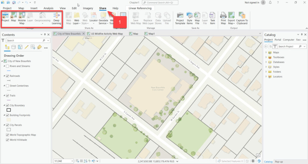
Packaging tools can be accessed in ArcGIS Pro through the Share tab. The ribbon presents the user with several package tools including Project Map, Mobile Map, Layer, Geoprocessing, and Deep Learning as seen in the screenshot below.
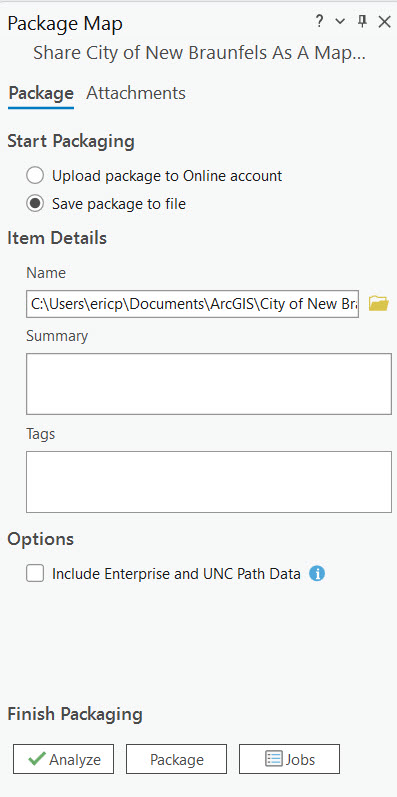
When any of these tools are clicked a geoprocessing tool will be displayed as seen below with the Map Package tool. The interface for all the packaging tools will be similar.
The default behavior is to save the package to a local file either on the computer where the tool is running or an accessible network drive. The other option is to upload the package to an ArcGIS Online/Portal account.
You will also be prompted to enter a summary and tags. It’s important to be as descriptive as possible with these parameters, particularly if you intend to upload to ArcGIS Online/Portal. When a user is searching for content, the search terms they enter will be compared to the summary and tags that you provide so the more descriptive you can be the easier for end users to find the package.
Before creating the package file you’ll need to first click the Analyze button on the geoprocessing tool. This will examine your content for any potential errors. Any errors will need to be corrected before clicking the Package button.
Conclusion
ArcGIS Pro packages represent a significant step forward in the world of GIS. They not only enhance the efficiency of data sharing and management but also ensure consistency and reliability in GIS operations. Whether it’s for individual use or collaboration across large teams, the packaging feature of ArcGIS Pro is an indispensable tool in the arsenal of modern GIS professionals. As GIS technology continues to evolve, features like these will play a crucial role in shaping the future of spatial analysis and decision-making.
