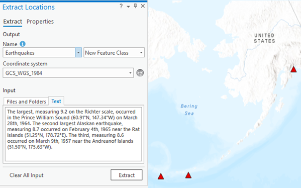
A new ArcGIS Pro extension searches unstructured data for spatial locations and generates point features representing those locations.
The latest version of ArcGIS Pro, version 2.3, introduces a new extension named LocateXT (Locate Extract) that automatically scans unstructured documents for spatial locations. These can be anything from text files, Microsoft Word documents, web pages, emails, social media text to PowerPoint presentations. After scanning the documents, any spatial locations found are extracted, from which point features are mapped in ArcGIS Pro’s map window. Additional information from the documents can be stored in the accompanying attribute table that is created with the new feature(s).
The Extract Locations pane that offers this functionality can be found from the Add Data drop-down menu. Additionally, two geoprocessing tools (Extract Locations From Documents and Extract Locations From Text) perform the same functionality and can be found in the Conversion toolbox in the To Geodatabase toolset. This makes it possible to use the tools when automating spatial workflows using Python scripts.
How it works
LocateXT uses IFilters to analyze documents. An IFilter is a plugin that allows Microsoft’s search engines to index various file formats so that they become searchable. An IFilter acts as a plug-in for extracting full-text and metadata for search engines.
Normally, a document is indexed by a search engine and data is created to store the indexing result. This way, any keyword search can quickly be indexed by the user by looking up the indexing result. LocateXT works a little different as it uses default parameter values in order to optimize the identification of coordinates and dates. These default settings for each parameter can be adjusted to optimize the search and output using the Properties tab.
Using the Options tab allows further customization for performing a location search. Coordinates, Custom locations, Fuzzy match, Custom attributes, and Dates are different parameters that can be used for a location search. You can limit the amount of files you want to search in case you add entire folders, so that only a selection of documents is searched. Because the tool works does not use any form of Artificial Intelligence, it is possible that the results are not entirely correct. For example, regular numbers can be mistaken for coordinates or fuzzy matching can result in false positives.
ArcGIS Pro Classes
- Learning ArcGIS Pro 1: Maps and Projects
- Learning ArcGIS Pro 2: Editing, Analysis, and Automation
- Learning ArcGIS Pro 3: Converting, Linking, and Analyzing Data
- Learning ArcGIS Pro 4: Sharing Your Maps and Data
- Introduction to Programming ArcGIS Pro with Python
- Intermediate ArcGIS Pro with Python
- Getting Started with ArcGIS Arcade
- ArcGIS Pro Bundle
- Annual GIS Training License

