

Studies suggest that over the past few decades, the number and size of wildfires have increased throughout the western United States. The average length of wildfire season has increased significantly as well. According to the Union of Concerned Scientists (UCS), every state in the western US has experienced an increase in the average annual number of large wildfires (greater than 1,000 acres) over the past few decades. The Pacific Northwest, including Washington, Oregon, Idaho, and the western half of Montana have had a particularly challenging 2017 wildfire season.
Extensive studies have found that large forest fires in the western US have been occurring nearly five times more often since the 1970s and 80s. Such fires are burning more than six times the land area as before, and lasting almost five times longer.
Climate change is thought to be the primary cause of the increase in large wildfires with rising temperatures leading to earlier snow melts, decreased precipitation, and forest conditions that are drier for longer periods of time. An increase in forest tree disease from insect disturbance has also been associated with climate change and can lead to large areas of highly flammable dead or dying forests. Other potential causes of increased wildfire activity include forest management practices, and an increase in human caused wildfires due to accidents or arson.
Monitoring Trends in Burn Severity (MTBS) is an interagency program whose goal is to consistently map the burn severity and extent of large fires across all lands of the United States from 1984 to present. This includes all fires 1000 acres or greater in the western United States and 500 acres or greater in the eastern Unites States. The extent of coverage includes the continental U.S., Alaska, Hawaii and Puerto Rico. The MTBS site includes downloadable GIS datasets for the entire nation or by individual state.
So, have wildfires actually increased, or does it just seem that way because we’re tuned in more to bad news and social media? Geospatial Training Services recently completed a project to analyze the spatial and temporal distribution of large wildfires in the Pacific Northwest using the MTBS datasets. The results of our findings are presented below.
Data Preparation
We used two MTBS datasets: Fire Occurrence Dataset (point), Burned Areas Boundaries (polygon). The datasets include an attribute field that can be used to segment the data by zone. This includes a Pacific Northwest identifier for Oregon, Washington, Idaho, and western Montana, which was used to segment the data.
Software
We used ArcGIS Pro with the Spatial Statistics toolbox. Tools used include Hot Spot Analysis, Optimized Hot Spot Analysis, Cluster and Outlier Analysis, and Space Time Pattern Modeling. Charts were created with ArcGIS Pro and MS Excel.
Distribution of Wildfires in the Pacific Northwest
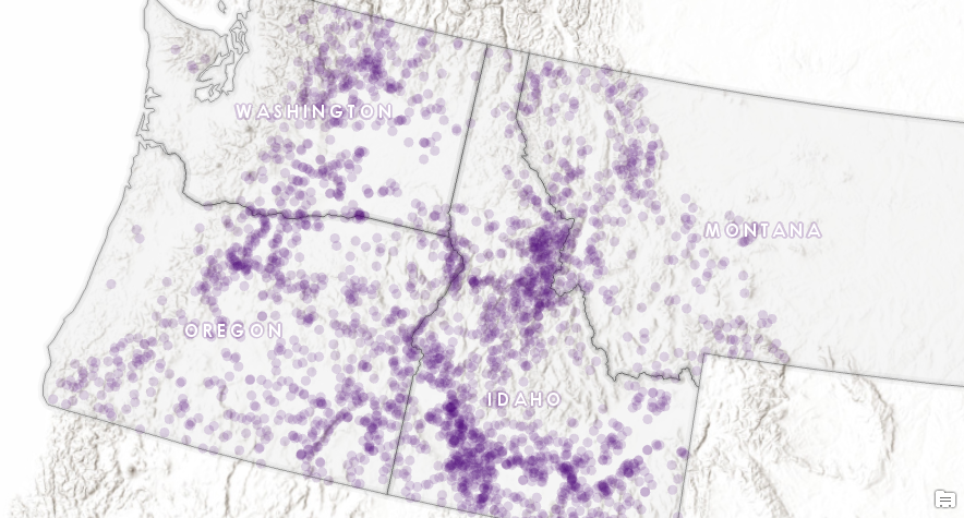
The two maps below illustrate the distribution of large wildfires (greater than 1,000 acres burned) in the Pacific Northwest between 1984 and 2015. The first map displays wildfires using the MTBS point dataset. You can see some obvious patterns in the distribution simply by looking at this map, but we’ll apply spatial statistics tools as well to get a better sense of how the data is distributed.
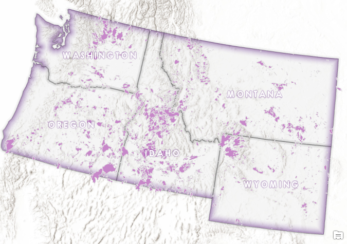
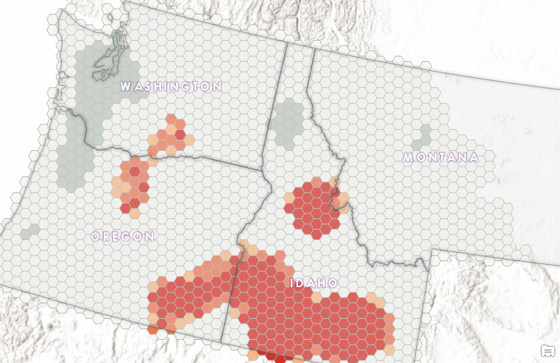
The map below illustrates the burn perimeters for all wildfires greater than 1,000 acres. Again, you can see the obvious concentrations of wildfires in central Idaho, northern Washington, southeastern Oregon, and the northwest corner of Wyoming.
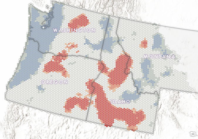
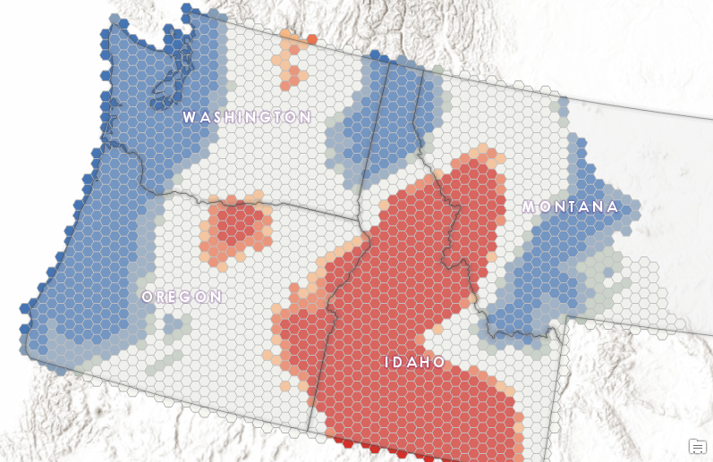
Next, we used the Hot Spot Analysis and Optimized Hot Spot Analysis tools found in the Spatial Statistics toolbox in ArcGIS Pro on the point layer containing wildfires from 1984-2015 to produce a map of hot spot, cold spot, and statistically not significant areas using a hexagon structure. Areas in a shade of red below have been identified as hot spots of various confidence levels (90%, 95%, and 99% confidence levels). Areas in shades of blue have been identified as cold spots of the same confidence levels, and areas in white are not statistically significant.
Now the distribution of wildfires really stands out in a statistically significant manner. Large swathes of southern and central Idaho, northern Washington, northern and southeastern Oregon, and a small area in western Montana are clearly prone to large wildfires. As expected due to high annual precipitation the coastal areas of Oregon and Washington are cold spots. Northern Idaho, large sections of Montana, and a smaller section of central Idaho between hot spots were also identified as cold spots.
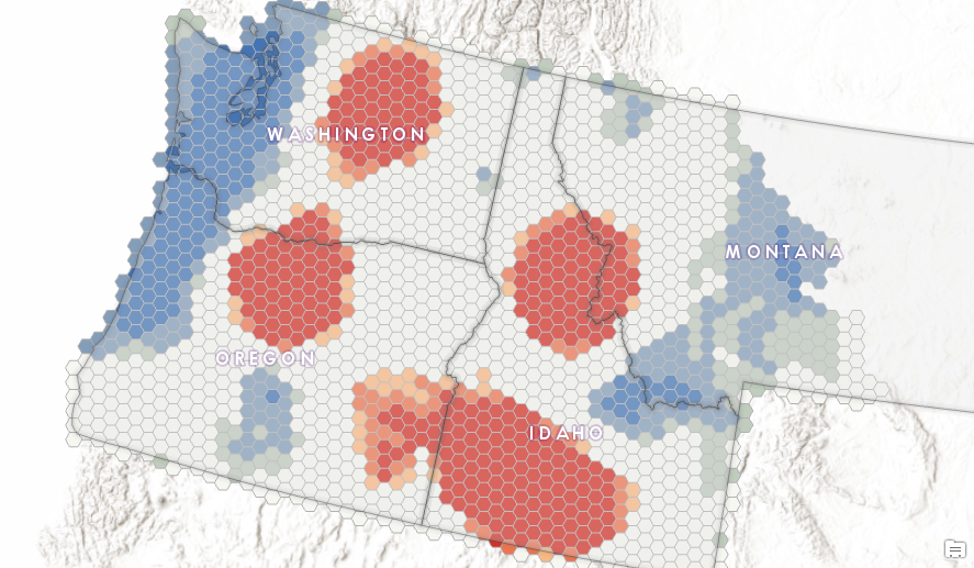
Next, we divided the data into 7 year time periods including 1984-1991, 1992-1999, 2000-2007, and 2008-2015 to see if the distribution of wildfires varied over time.
1984-1991
1992-1999
2000-2007
2008-2015
Spatial-Temporal Distribution
To get a better look at the trends in large wildfire activity over time we then used the Emerging Hot Spot Analysis tool found in the Space Time Pattern Mining toolbox along with the Create Space Time Cube and Space Time Cube Explorer Addin for ArcGIS Pro. The Emerging Hot Spot Analysis tool finds new, intensifying, diminishing, and sporadic hot and cold spots, for example.
In GIS, much of our analysis deals with understanding the spatial patterns of our data. However, there are many times when we also need to understand a phenomenon in both space and time. We can expand our idea of things that are closer in space and are more alike to include the idea that things closer in space and time are more related. I’ve written previously about the space time pattern mining tools available in ArcGIS Pro and ArcGIS Desktop if you’d like more information on this topic.
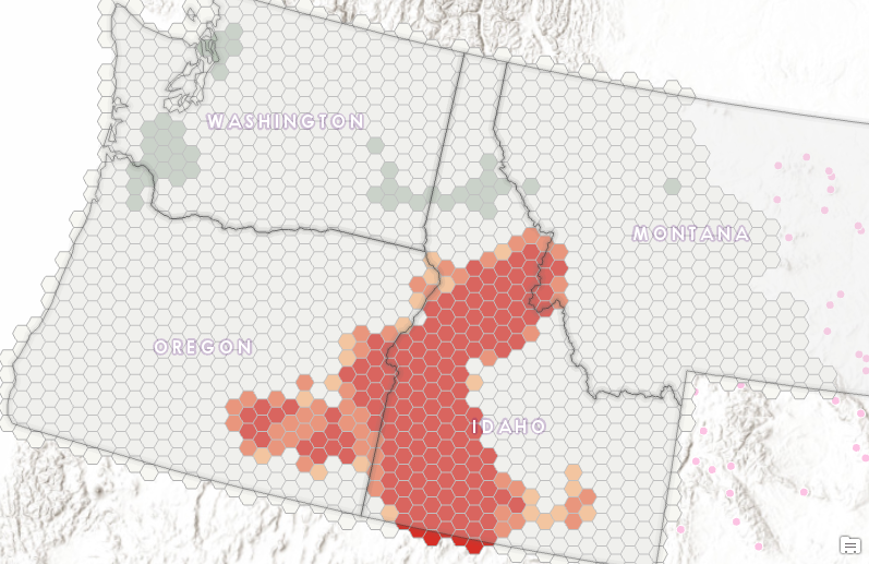
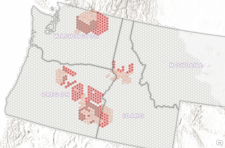
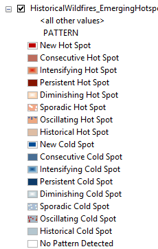
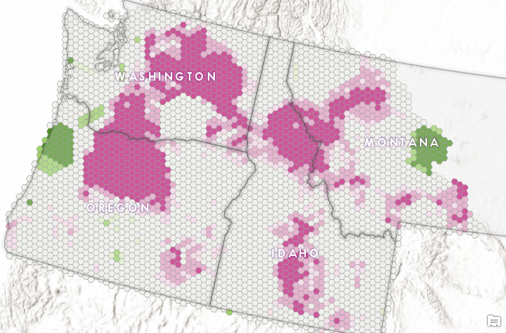
The map below illustrates the output from the Emerging Hot Spot Analysis tool for the MTBS dataset. A legend is provided just below the map. The legend includes a large number of potential categories so I’ll further explain the categories found in our dataset.
The hexagons symbolized in red as New Hot Spots are areas that were identified as new for the most recent year (2015) in comparison to previous years (1984-2014). The Emerging Hot Spot Analysis tool is used for trend analysis of a dataset over time. New Hot Spots indicate a location that is a statistically significant hot spot for the final time step (2015 in this case) and has never been a statistically significant hot spot before. As you can see in the map below the tool has identified a number of fairly large areas of new hot spots. These ar areas that have never been hot before, but were in 2015.
Hexagons symbolized as Consecutive Hot Spots have been hot for a number of years consecutively. These are locations with an uninterrupted run of statistically significant hot spot bins in the final time-step intervals.
Finally, hexagons symbolized as Sporadic Hot Spots have been hot sporadically over the time period (1984-2015). These locations show an on-again then off-again hot spot.
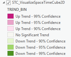
We also looked at trend analysis with the Space Time Cube Explorer Addin for ArcGIS Pro. Large areas of central Oregon and Washington were identified as having an upward trend in the occurrence of large wildfires. The same trend was identified in large parts of Idaho and western Montana.
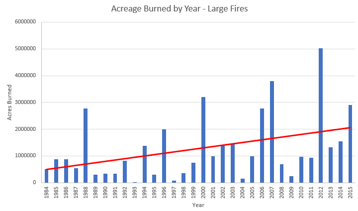
Finally, we used ArcGIS Pro and Microsoft Excel to visualize the data using bar charts and trend lines. Charts show a clear uptick both in the number of acres burned as well as the number of large wildfires.
Conclusions
The occurrence of large wildfires in the Pacific Northwest has clearly increased in both number and the amount of acreage burned. Large areas of Oregon, Washington, and Idaho are increasingly susceptible to these large wildfires as illustrated in our trend analysis. Central and southern Idaho have been and continue to be hot spots of large wildfire activity along with sections of northern Oregon and Washington.
We plan to further analyze the dataset to determine if the onset of fire season is becoming earlier and to see if the fire season is lasting longer.
More information
Our class – Introduction to Spatial Statistics using ArcGIS and R
Our services – Spatial Analytics and Data Science
Part 1 – Analyzing Wildfire Activity with Spatial Analytics
Part 2 – Analyzing Wildfire Activity with Spatial Analytics
