

How often have you found out about a game-changing ArcGIS Pro feature months after it launched? Or continued using a time-consuming workflow, only to discover a better, faster option was already available?
Staying current with software updates often means constantly checking blogs, wading through release notes, or simply stumbling upon improvements by chance.
ArcGIS Pro 3.6 is changing this with a powerful new feature: Announcements.
What Are ArcGIS Pro Announcements?
Announcements deliver critical updates and information about ArcGIS Pro directly inside the application.
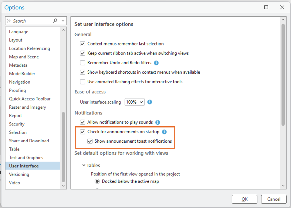
Instead of having to leave your work to hunt for information on external websites, you’ll see timely updates right where you are—within ArcGIS Pro itself. These messages appear as clean, non-intrusive banners, ensuring you get the information you need without breaking your focus.
Why This Matters: The Benefits to You
The biggest challenge for any ArcGIS Pro user isn’t just learning the software—it’s keeping up with its rapid evolution. Announcements solve this simple but crucial problem by bringing the information to you.
| Benefit | How It Helps Your Work |
| Work More Efficiently | Discover performance enhancements and improvements to the tools you already use, eliminating old, slow workflows. |
| Discover Features Faster | Learn about new tools and capabilities the moment they’re released, maximizing your utilization of the software. |
| Stay Current Effortlessly | Important updates, bug fixes, and best practices are delivered to you automatically while you work, saving you time and effort. |
| Avoid Surprises | Stay informed about important changes like deprecated features or new requirements that could affect your projects. |
What You Can Expect to Learn About
Announcements are a curated feed designed to keep you informed about what truly matters:
- 🚀 New Features: Be the first to try out exciting new capabilities.
- ✅ Software Improvements: Get details on performance upgrades and bug fixes.
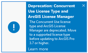
- ⚠️ Important Changes: Stay aware of workflow shifts, feature retirements, and requirements.
- 💡 Tips & Best Practices: Find guidance on more efficient ways to use Pro features.
- 📚 Training & Resources: Discover new webinars, learning paths, and helpful documentation.
Making the Most of the New Feature
When ArcGIS Pro 3.6 arrives, make sure you take these simple steps to benefit fully:
- Read Before You Dismiss: Announcements are curated to be useful and relevant. Take a moment to scan the content.
- Follow the Links: If a topic interests you, follow the provided links to additional resources or documentation to dive deeper.
- Try It Out: If a new feature is highlighted, spend a few minutes exploring it. It might be the solution you’ve been needing!
Announcements make staying informed about ArcGIS Pro simpler than ever. Esri is shifting toward proactive communication, ensuring the most important information comes directly to you in your daily workflow. This means you can keep pace with the software and leverage its full capabilities without having to read every single release note.
Ready to maximize your ArcGIS Pro skills and put these new updates to work immediately?
Geospatial Training Services offers customized training programs tailored to your exact needs. Contact us at [email protected] to learn more about a training solution for you or your team.
