

Learn more about ArcGIS Pro in our introductory Mastering ArcGIS Pro 3: Maps, Layers, Projects, and Layouts class and our intermediate level Mastering ArcGIS Pro: Editing, Analysis, and Automation class.
The May 2025 release of ArcGIS Pro 3.5 delivers significant improvements across data handling, editing capabilities, analytical tools, and user experience. This update emphasizes performance optimization, intelligent workflows, and expanded data interoperability to meet the evolving needs of GIS professionals.
Revolutionary Data Format Support
ArcGIS Pro 3.5 introduces native support for Apache Parquet and GeoParquet formats, marking a significant step toward big data integration. These columnar storage formats, widely adopted in data science and cloud analytics platforms, can now be directly incorporated into maps and scenes.
Key Benefits:
- Seamless integration with platforms like Databricks, Apache Spark, and Snowflake
- Enhanced performance for large-scale spatial datasets
- New
CreateParquetCacheArcPy function for local caching and accelerated rendering
This advancement bridges the gap between traditional GIS and modern data science workflows, enabling more efficient collaboration across disciplines.
Intelligent Editing Workflows
The editing experience receives substantial upgrades focused on precision and efficiency:
Advanced Vertex Visualization
- Customizable symbols for different vertex types (vertices, dangles, pseudonodes, endpoints)
- Improved visual clarity for complex editing tasks
- Better quality control for network and polygon editing
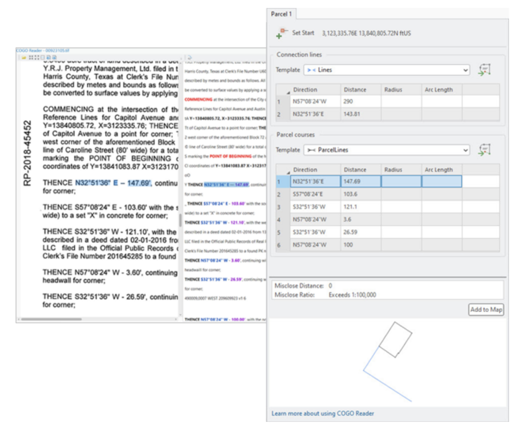
COGO Reader Tool A breakthrough feature for land records professionals, this tool uses optical character recognition (OCR) to extract coordinate geometry data from scanned survey documents and automatically convert them into construction lines for parcel creation.
Enterprise and Utility Network Enhancements
Several tools target enterprise data management and utility network optimization:
Utility Network Migration Wizard
- Streamlined creation of domain networks
- Automated schema mapping capabilities
- Reduced complexity for utility data migration projects
Performance Optimization Tools
- Prune Branch History Tool: Removes unnecessary historical records from branch-versioned geodatabases
- Memory Workspace Option: Routes temporary geoprocessing outputs to memory instead of disk, significantly speeding up complex workflows
Advanced Predictive Analytics
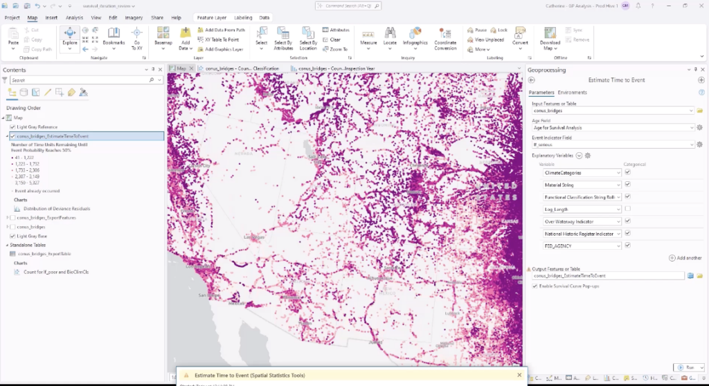
The new Estimate Time to Event geoprocessing tool introduces powerful forecasting capabilities:
- Model infrastructure failure predictions
- Analyze customer behavior patterns over time
- Forecast environmental changes based on historical data
- Applications span from asset management to risk assessment
AI-Powered User Experience
ArcGIS Pro 3.5 integrates artificial intelligence to create more intuitive workflows:
Intelligent Tool Discovery
- Enhanced semantic search with improved keyword recognition
- Contextual tool suggestions based on current workflows
- Post-processing recommendations for logical next steps
Privacy-First Design All AI enhancements run locally on your machine—no data transmission to external servers, ensuring complete data privacy and security.
Modernized Cartography and Layout Features
Workspace Management
- Pane Sets: Save and instantly recall custom pane configurations
- Optimized for switching between editing, analysis, and cartographic tasks
- Improved multitasking capabilities
Enhanced Publishing
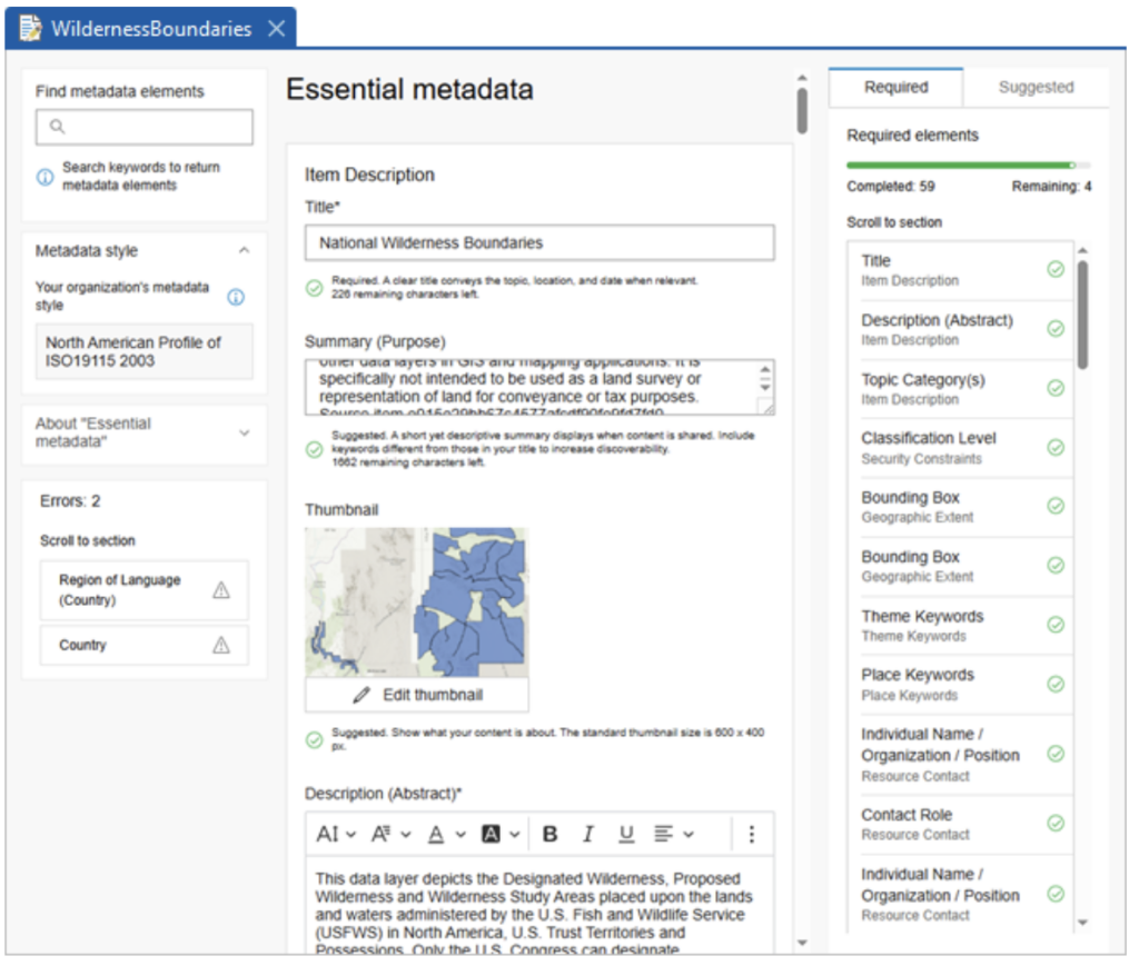
- Updated ArcGIS Metadata Editor matching ArcGIS Online standards
- Direct PDF integration in maps without format conversion
- Interactive hyperlink support in layout text elements
- Streamlined report creation and sharing
Licensing Updates and Deprecations
New Inclusions
- LocateXT extension now bundled with Pro Standard and Advanced licenses
- Streamlined licensing reduces additional extension requirements
Retired Features
- ArcGIS Workflow Manager Classic
- Workflow toolset from Topographic Production toolbox
- VBScript support in Network Analyst evaluators
Note: Existing workflows using these features will continue to function, but migration to supported alternatives is recommended.
Looking Forward
ArcGIS Pro 3.5 represents Esri’s commitment to intelligent, high-performance GIS solutions. By combining advanced data science integration, AI-enhanced user experiences, and robust analytical tools, this release positions ArcGIS Pro at the forefront of modern spatial analysis.
The emphasis on performance optimization, intelligent workflows, and expanded data compatibility ensures that GIS professionals can tackle increasingly complex challenges while maintaining productive and efficient workflows.
Discover all features and improvements in the complete ArcGIS Pro 3.5 release documentation.
Learn more about ArcGIS Pro in our introductory Mastering ArcGIS Pro 3: Maps, Layers, Projects, and Layouts class and our intermediate level Mastering ArcGIS Pro: Editing, Analysis, and Automation class.
