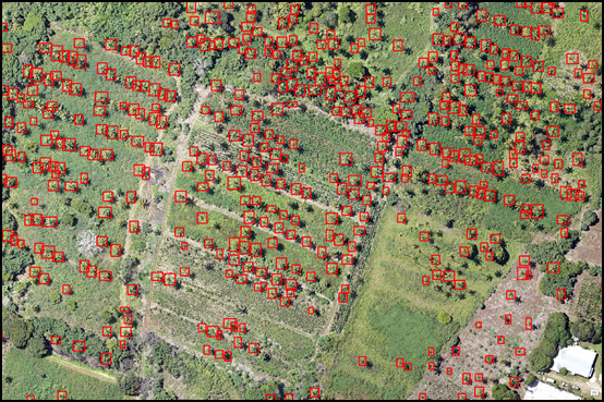
The latest version of ArcGIS Pro features new deep learning tools that let users train their data in an external deep learning model and use the results to model or classify their imagery within the ArcGIS platform.
What is deep learning and how can it improve geospatial workflows?
Deep learning is a type of machine learning that uses deep (or many layered) artificial neural networks. This is software that roughly emulates the way neurons operate in the brain. Deep learning has been the primary driver of the AI revolution of the last decade.
ArcGIS has supported several statistical and machine-learning classification tools for years. Now, Esri is enabling users to integrate ArcGIS with external deep learning modeling systems that utilize convolutional neural networks. These are machine learning architectures inspired by the brain’s visual cortex. New deep learning tools in ArcGIS Pro enable users to train their data in an external deep learning model, and then use the results of the model to classify their imagery within the ArcGIS platform.
This way, ArcGIS can now train algorithms to recognize specific features and or classify raster pixels into different categories. These can be used to speed up current workflows that involve a lot of manual labor, as these algorithms can process and classify large quantities of data better and faster than humans. This is done through a process called supervised learning, where manually categorized or labeled data is provided to a learning algorithm.
New feature extraction and image classification tools in ArcGIS Pro
The ArcGIS Pro Image Analyst extension features three new deep learning tools:
- Classify Pixels Using Deep Learning tool
- Detect Objects Using Deep Learning tool
- Non Maximum Suppression tool
These tools support image classification and object detection workflows that use deep learning models generated by deep learning frameworks such as TensorFlow, CNTK, and Keras. The first tool runs a trained deep learning model on an input raster to produce a classified raster. The second tool runs a trained deep learning model on an input raster and produces a feature class layer containing the objects it finds in imagery. The third tool identifies and eliminates duplicate features from the output of the second tool. These tools rely on external Python functionality: the proper deep learning framework Python API needs to be installed into the ArcGIS Pro Python environment.
New Deep Learning experiments with 3D data
Taking deep learning one step further, the people at Esri have been using these new deep learning tools as part of new workflows for extracting building information from 3D spatial data. At Esri’s GeoAI publication on medium.com, several articles describe the results of different experiments. The experiments are quite innovative, as they combine advanced hardware and software solutions in order to get the best results possible with today’s technology. What’s interesting is that some of these experiments use 3D spatial data instead of 2D data, such as lidar and 3D meshes. One of the latest contributions shows how various geoprocessing tools from ArcGIS Pro’s can be used to reconstruct 3D building models using raw point clouds. It also anticipates how open source deep learning models can be used in 3D volumetric spaces such as voxels.
ArcGIS Pro Classes
- Learning ArcGIS Pro 1: Maps and Projects
- Learning ArcGIS Pro 2: Editing, Analysis, and Automation
- Learning ArcGIS Pro 3: Converting, Linking, and Analyzing Data
- Learning ArcGIS Pro 4: Sharing Your Maps and Data
- Introduction to Programming ArcGIS Pro with Python
- Intermediate ArcGIS Pro with Python
- Getting Started with ArcGIS Arcade
- ArcGIS Pro Bundle
- Annual GIS Training License

