ArcGIS Pro enables the creation of raster surface models (Digital Elevation Models and derivatives such as a Digital Surface Model) from lidar point cloud data.
Digital Elevation Models and derivatives such as Digital Surface Models and Digital Terrain Models are often derived from stereo imagery. However, they can also be generated using point cloud data captured from aerial lidar. ArcGIS Pro offers various lidar geoprocessing tools that enable the creation of raster surface models based on point cloud data. The workflow is as follows:
- Populate one ore more point clouds in a single LAS dataset
- Generate LAS dataset layers for the appropriate points used for the raster surface models
- Convert these point cloud data layers into raster surface models
The workflow is described into more detail below.
Using ArcGIS Pro to populate a point cloud in a LAS dataset
ArcGIS Pro enables working with point clouds in the native LAS format. The LAS (LASer) format is an open file format designed for the interchange and archiving of lidar point cloud data. A LAS file contains the x, y and z values of all collected points, as well as classification values for each point, that refer to the surface of the point (such as a building or terrain), apart from other metadata.
A LAS point cloud dataset can be added to a map or scene from the Catalog pane. When you’re zoomed out only a bounding box is displayed in the map window, but no actual point cloud data. The symbology menu (Appearance), lets you symbolize the points based on elevation, class, return, or intensity, with elevation being the default symbology. You can also view a subset of points by their classification or return attributes, by going into the layer properties and make a selection using the LAS filter.
ArcGIS Pro enables the creation of a separate LAS Dataset, that functions as a container for point clouds and offer additional functionality not found in natively stored point clouds. It is recommended to create one when generating raster surface models later on. You can populate a LAS dataset with one or more point clouds with the “Add Files to LAS Dataset” geoprocessing tool. After creating the LAS Dataset inside Pro using your own LAS files, it’s possible to use some of the functionality within the LAS Dataset Layer tool dialog in ArcGIS Pro, such as the LAS Dataset Statistics Tool, that gives you detailed information regarding the classifications including both total point counts, percent, Z-values and more.
Generating LAS dataset layers for the appropriate points for creating raster surface models
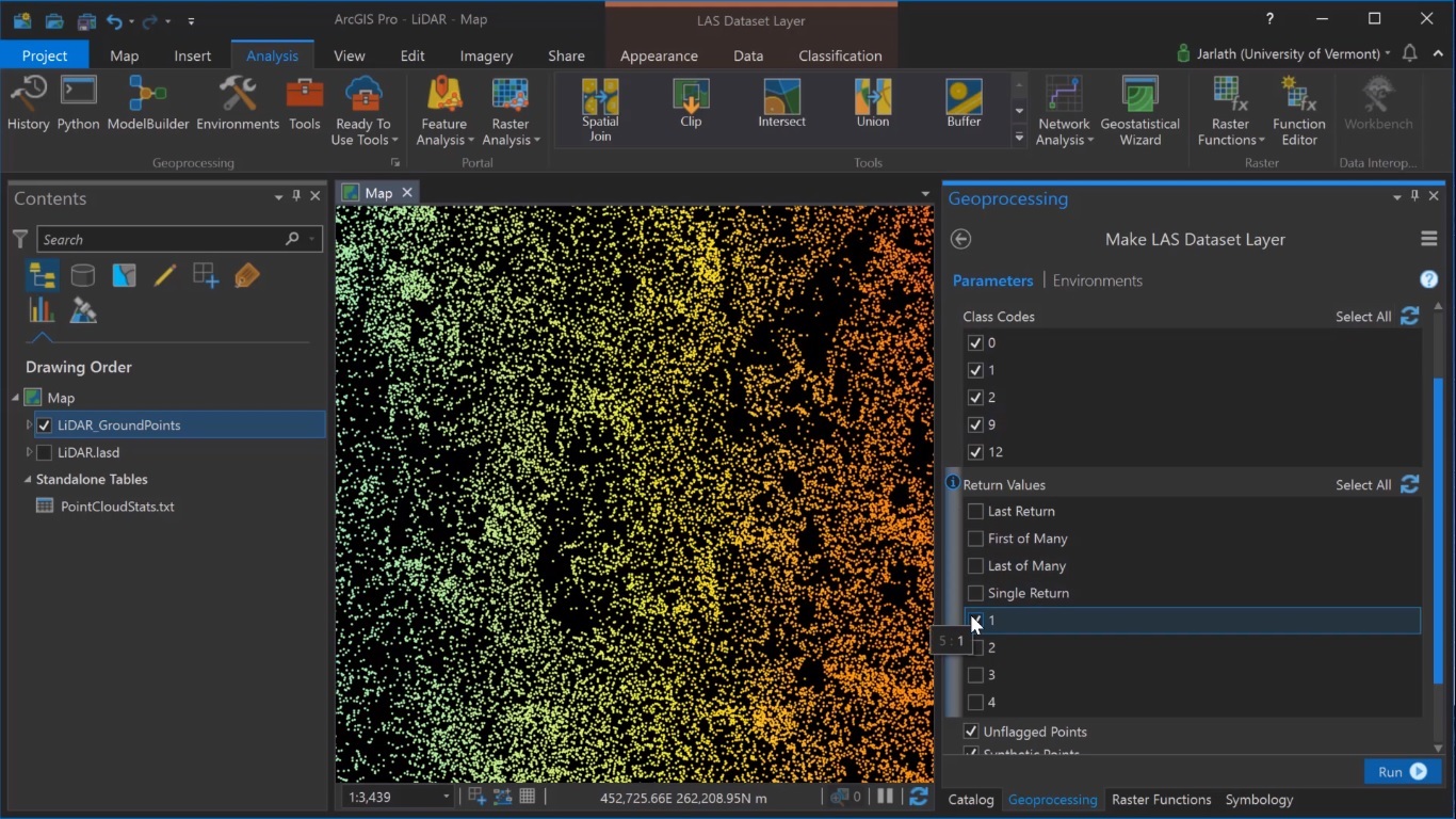
The next step is to create a subset of the newly created LAS dataset, containing only the ground points. These points are required for the raster surface models to be generated later. The selection can be made using the “Make LAS Dataset Layer” tool that takes an input LAS dataset and a selection, in this case, the classification code of the number 2, which refers to only the ground points. Clicking “Run” will create a new virtual layer containing only the points that are classified as ground. Optionally, the same tool can be used to generate a second LAS dataset layer for points that are first returns. These are necessary when generating a Digital Surface Model, a raster representation of the true 3D surface of all features including buildings and trees which wouldn’t exist in the ground point classification and hence wouldn’t be present in the DEM.
Converting the newly created virtual layers into raster surface models
To convert the first return and ground point layers to respective raster surface models, the “LAS Dataset To Raster” geoprocessing tool can be used. This will export the LAS datasets to a raster format. The virtual ground points layer can be exported to a Digital Elevation Model representing the topographic bare-earth surface. When storing the output raster inside a geodatabase, you can select the interpolation type, such as triangulation “(interpolation type”) and natural neighbor with no thinning (“interpolation method and thinning type”). When choosing the sampling type, you can use the point spacing value gathered from the LAS dataset statistics for the cell size. The same workflow can be repeated for the second virtual LAS data layer.
Using ArcGIS Pro raster functionality and subtracting the DEM from the DSM, a Normalized Digital Surface Model is created (NDSM). This layer represents the height aboveground. This output layer is not a raster file, but a virtual dataset that exists within an ArcGIS Pro project. To improve the cartographic appearance, you can generate a hillshade using once again the ArcGIS Pro raster functionality, place the hillshade underneath the NDSM layer, and apply transparency and symbology to the NDSM layer. This visualization makes it easier to identify features on the landscape. The pixel values of the NDSM represent the height of features aboveground in map units, so clicking on the roof of an individual building returns its height.
Sources:
LiDAR Surface Models in ArcGIS Pro, Jarlath O’Neil-Dunne
LAS File format, Wikipedia

