

ArcGIS Experience Builder’s latest update introduces a suite of enhancements designed to improve functionality, accessibility, and user experience. Here’s an overview of the key updates:
Accessibility Enhancements
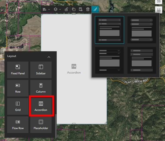
Accessibility continues to be a priority in this release. The Accordion widget now supports enhanced accessibility features, ensuring content is accessible to all users. Custom filters within the Filter widget have been upgraded to support keyboard navigation, promoting a more inclusive user experience. Additionally, theme settings now allow customization of the focus indicator color, providing clearer visual cues for interactive elements.
Expanded Data Actions
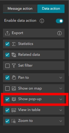
Two new data actions have been introduced to enhance data interaction within applications:
-
Select: Enables users to select loaded records directly from the app interface.
-
Show Pop-up: Displays pop-ups on the map for selected, loaded, or current records, facilitating dynamic interaction with spatial data.
These actions provide users with more intuitive ways to engage with map-based content.
New Widgets and Templates
New Widgets
Several new widgets have been added to expand the functionality and customization options within Experience Builder:
-
Flow Row Widget: A layout container that positions content in a continuous horizontal row on a page. Unlike the traditional Row widget, which divides the area into 12 discrete columns, the Flow Row widget offers a seamless flow, similar to a scrolling page or the Column widget. When a widget is removed from a Flow Row, the remaining widgets automatically adjust to fill the space.
-
Oriented Imagery Viewer Widget: Enables interaction with and visualization of oriented imagery layers. This includes imagery captured from various angles—such as oblique, street-side, inspection, and 360-degree images—in both 2D maps and 3D scenes. Sources can range from mobile cameras and drones to terrestrial sensors.
-
Processing Templates Widget: Allows users to apply raster function templates to associated imagery layers. These templates, known as raster function templates, are reusable items that can contain one or more raster functions chained together, enabling dynamic image processing and analysis.

New Templates
To provide more design flexibility, several new templates have been introduced:
-
Poster Window Template: Designed for creating informative pop-up windows, ideal for highlighting specific content or announcements within an application.
-
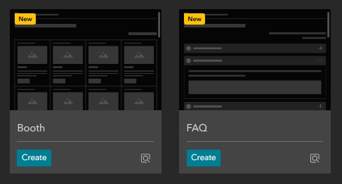
Booth Scrolling-Page Template: A vertically scrolling template suitable for showcasing content in a booth-style layout, perfect for presentations or product displays.
-
FAQ Scrolling-Page Template: Designed to present frequently asked questions in a user-friendly, scrollable format, enhancing user engagement and information accessibility.
-
Catalog Full-Screen Page Template: Offers a full-screen layout ideal for displaying catalogs or extensive content, providing an immersive user experience.
-
Prism Multi-Page Template: A multi-page template featuring a modern design, suitable for applications requiring structured navigation across multiple sections or topics.
These additions empower users to build customized applications that align with their specific workflows and design preferences.
General Settings and Privacy Controls
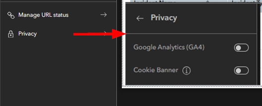
A new Privacy section has been added to the General settings tab, providing developers with greater control over how applications handle user data. This includes options to integrate Google Analytics and configure cookie consent banners, ensuring compliance with privacy standards and enhancing user trust.
Support for Additional Data Types
Experience Builder now supports four new data types, broadening its data integration capabilities:
-
Building Scene Layers: Enables detailed 3D visualization for urban and architectural models.
-
Imagery Layers: Allows direct integration and visualization of satellite and aerial imagery.
-
Oriented Imagery Layers: Supports specialized imagery formats such as street-level and drone imagery.
-
Subtype Group Layers: Enhances data organization by grouping related subtypes within a single feature layer.
These additions provide GIS professionals with more options for managing and displaying complex datasets.
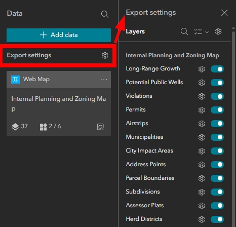
Export Settings
A notable enhancement in this update is the introduction of Export Settings, offering users greater control over data export functionalities:
-
Export Settings Panel: Accessible from the Data panel in the builder, this new panel displays all maps and scenes in the application along with their supported layers. Developers can enable exporting and select supported file formats (such as CSV, JSON, GeoJSON, and ArcGIS items) for individual layers. Batch options are also available to apply export settings across multiple layers simultaneously.
-
Widget-Specific Export Options: Certain widgets, like the Near Me and Table widgets, now support data export actions. By enabling the export data action in these widgets’ settings, users can export analysis results or selected records at runtime, facilitating data sharing and further analysis.
These export enhancements empower users to extract and utilize data more effectively, enhancing the overall functionality of applications built with Experience Builder.
Final Thoughts
The latest updates to ArcGIS Experience Builder demonstrate a continued commitment to enhancing usability, expanding functionality, and ensuring inclusivity. With new widgets, templates, data actions, and export capabilities, users are equipped with powerful tools to create interactive and feature-rich applications tailored to their specific needs.
