
Now is the time to start leveraging the power of the Task Framework in ArcGIS Pro! Learn more about the Task Framework in our Geoprocessing Automation in ArcGIS Pro with Tasks class!
Efficiency and consistency are crucial for managing complex GIS workflows. ArcGIS Pro’s Task Framework offers a powerful way to streamline geoprocessing workflows, automate repetitive tasks, and enhance team collaboration. Whether you’re working in city planning, environmental management, appraisal districts, or emergency response, understanding and leveraging tasks can revolutionize your operations.
This article explores the key features of the Task Framework, and real-world applications where it makes the biggest impact.
ArcGIS Pro Automation: Three Core Methods
When automating workflows in ArcGIS Pro, users have three main options:
1️⃣ ModelBuilder – Visual Automation Without Code
ModelBuilder provides a drag-and-drop visual programming environment, allowing users to automate geoprocessing tasks without any coding experience. It is particularly useful for:
✔ Building reusable workflows
✔ Exporting models to Python scripts for advanced automation
✔ Users who prefer a graphical approach to workflow design
2️⃣ Python – Full Control Over Automation
Python scripting offers unparalleled flexibility and power for automation in ArcGIS Pro. It allows users to:
✔ Script complex processes and integrate third-party libraries
✔ Automate workflows within or outside of ArcGIS Pro
✔ Customize GIS operations for unique project needs
However, Python has a steeper learning curve, making it ideal for advanced users requiring custom solutions.
3️⃣ The Task Framework – The Best of Both Worlds
Tasks serve as a middle ground between ModelBuilder and Python, offering step-by-step guidance without requiring programming knowledge. Tasks are great for:
✔ Semi-automation with guided workflows
✔ Standardizing processes across teams
✔ Training new users with interactive instructions
By understanding these three automation tools, users can select the best fit for their projects. However, the Task Framework is uniquely suited for standardizing and streamlining workflows while ensuring ease of use.
What is the Task Framework in ArcGIS Pro?
The Task Framework in ArcGIS Pro is a structured workflow tool that guides users through predefined steps to complete a process. It ensures accuracy, efficiency, and consistency, making it particularly valuable for teams handling repetitive or complex tasks.
With the Task Framework, users can:
✔ Break down intricate workflows into manageable steps
✔ Ensure tasks are executed in the correct order
✔ Automate tool execution to reduce manual effort
✔ Provide step-by-step instructions to minimize errors
This structured approach ensures that even complex GIS workflows are easy to follow and execute.
Why Use the Task Framework?
The Task Framework is not just about automation—it enhances productivity, accuracy, and collaboration. Here’s why organizations rely on it:
✔ Standardization & Consistency – Ensures that workflows are followed the same way every time.
✔ Error Reduction – Reduces mistakes by guiding users through each step.
✔ Collaboration & Training – Helps onboard new users and aligns teams to follow standardized processes.
✔ Time-Saving Automation – Replaces repetitive manual tasks with streamlined execution.
✔ Better Project Tracking – Provides built-in documentation and workflow history.
Whether you’re a GIS analyst, planner, or emergency responder, the Task Framework helps maximize efficiency.
Key Components of a Task
To use the Task Framework effectively, it’s important to understand its core components:
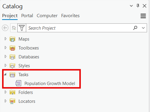
📂 Task Items
Task Items act as containers for workflows and can hold multiple related tasks. Task items are stored in the Catalog pane of a project.
📌 Task Groups
For better organization, Task Items can be grouped based on themes, projects, or departmental workflows.
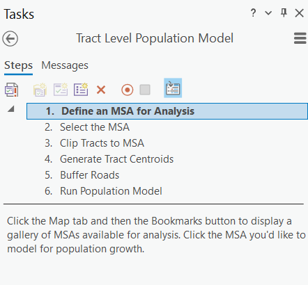
▶ Task Steps
Each task is broken down into individual steps, ensuring clarity and logical sequencing.
⚙ Settings & Dependencies
Users can customize workflows by:
✔ Setting dependencies between steps
✔ Defining user instructions
✔ Automating actions such as enabling layers or running tools
By leveraging these components, users can create intuitive, structured, and automated workflows.
How to Share and Access Tasks in ArcGIS Pro
Tasks in ArcGIS Pro seamlessly integrate into project files, making them easy to store, access, and share.
✔ Project-Based Access – Tasks are saved within ArcGIS Pro projects alongside maps, layouts, and data.
✔ Export & Share – Tasks can be exported as .esriTasks files for independent sharing.
✔ Cloud & Network Storage – Teams can share entire projects via network drives or cloud platforms.
✔ ArcGIS Online & Enterprise Portal – Tasks can be published online for broader access.
For smooth collaboration, always ensure that instructions, dependencies, and required datasets are well-documented when sharing tasks.
Advanced Capabilities of the Task Framework
Beyond basic workflows, the Task Framework supports:
✔ Automating Geoprocessing Models – Tasks can run complex ModelBuilder workflows.
✔ Conditional Logic for Dynamic Workflows – Tasks can adapt based on user input or intermediate results.
✔ Python Integration – Advanced users can embed Python scripts for additional automation.
These capabilities make the Task Framework a powerful tool for streamlining GIS operations.
Industry Applications: Where the Task Framework Excels
The Task Framework is widely used across industries to standardize and optimize workflows:
✔ City Planning – Automating zoning updates, land use analysis, and infrastructure planning.
✔ Environmental Management – Streamlining vegetation mapping, wildlife tracking, and conservation efforts.
✔ Appraisal Districts – Automating property assessments and tax evaluations.
✔ Wildfire Response – Providing structured evacuation plans and damage assessments.
✔ Transportation & Utilities – Managing infrastructure maintenance and network analysis.
By implementing tasks in these industries, organizations can reduce errors, increase efficiency, and ensure workflow consistency.
Best Use Cases for the Task Framework
The Task Framework is particularly useful in the following scenarios:
✔ Repetitive Workflows – Reduces manual effort and increases efficiency.
✔ Multi-Step Processes – Breaks down complex workflows into clear, manageable steps.
✔ Team Collaboration – Ensures all users follow the same structured process.
✔ Training & Onboarding – Helps new users learn workflows interactively.
✔ Error-Prone Processes – Provides structured guidance to prevent mistakes.
✔ Workflow Documentation – Tasks inherently track steps for auditability and knowledge sharing.
For teams managing large-scale GIS projects, the Task Framework is an essential tool for efficiency and accuracy.
Final Thoughts: Why You Should Start Using the Task Framework
The Task Framework in ArcGIS Pro bridges the gap between manual GIS workflows and full automation. It provides a structured, repeatable, and efficient way to manage geospatial processes, training, and collaboration.
Whether you’re automating a city planning project, optimizing environmental workflows, or training new GIS users, Tasks can help streamline your processes with ease.
💡 Now is the time to start leveraging the power of the Task Framework in ArcGIS Pro! Learn more about the Task Framework in our Geoprocessing Automation in ArcGIS Pro with Tasks class!
