
ArcGIS Pro Courses, COGO
Introduction to COGO Editing in ArcGIS Pro
IMPORTANT: This course does not cover Parcel Fabric or tools that are unique to Parcel Fabric.
This course is intended for beginner students who want to learn how to use Coordinate Geometry (COGO) tools in ArcGIS Pro to create, edit, and check geometry using bearings, distances, and curves. It is also designed for those professionals who are transitioning from using COGO in ArcMap and need to learn how to use COGO in ArcGIS Pro.
Before beginning this course, it is recommended that students are comfortable with basic ArcGIS Pro editing operations like creating and modifying features – though this is not strictly necessary. While formal surveying education isn’t required, familiarity with concepts like bearings, distances, and angles will help you grasp the material more quickly. Knowledge of different measurement units – feet, meters, degrees – is important since survey data comes in various formats. If you’re new to any of these concepts, consider reviewing the ArcGIS Pro editing basics course before proceeding.
Students need to have their own computer hardware and access to ArcGIS Pro. An ArcGIS Pro Standard or Advanced license is required.
- Module 1: Introduction to COGO & Basic Surveying Terminology
- Module 2: COGO Settings in ArcGIS Pro
- Module 3: COGO Workflow and Line Construction
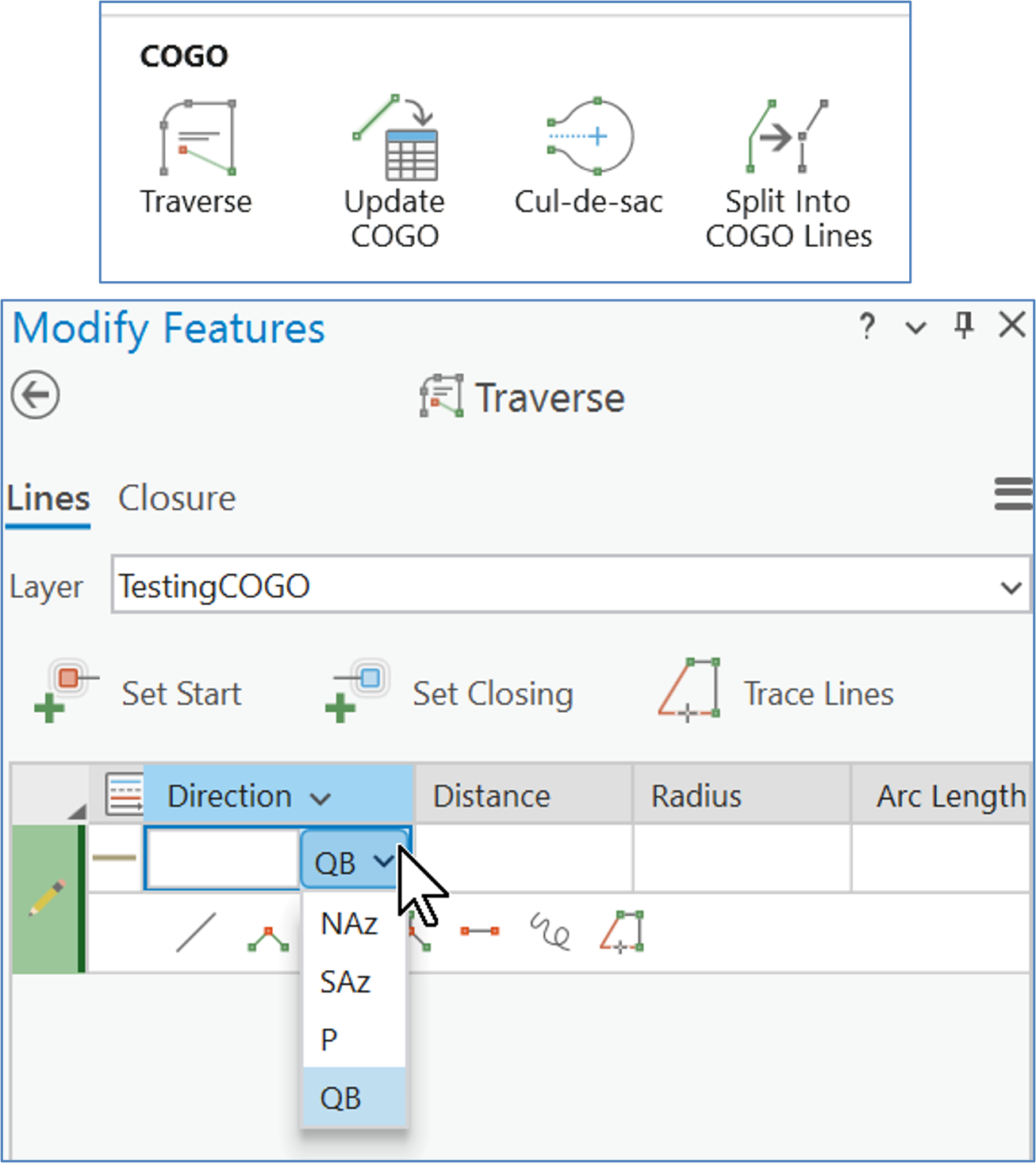
- Module 4: Working with the Traverse Tool
- Module 5: Update and Adjust Line Features
- Bonus Module 6: Construct Polygons from Line Features
This introductory course provides participants with a practical foundation in Coordinate Geometry (COGO) and traverse workflows within ArcGIS Pro. Designed for users who are new to COGO tools, the course emphasizes step-by-step workflows for entering bearings, distances, and curves; constructing traverses; validating geometry; and more.
Students will begin by learning the purpose of COGO in ArcGIS Pro and how to configure necessary and helpful Project settings before moving into feature creation and editing workflows. Hands-on exercises focus on using COGO-enabled tools, the Traverse pane, applying distance and direction-based edits, and ensuring accuracy through validation and adjustment methods. The course concludes with a bonus section that may be taught dependent on time. This bonus section focuses on generating polygons from linework, providing a complete workflow from setup to output.
By the end of the course, students will be able to confidently apply COGO methods in ArcGIS Pro to create, edit, check, and document geometry defined by bearings, distances, and curves.
Don’t want to purchase online? You can also register for classes using our registration form.
This course made it less intimidating to switch from ArcMap to ArcGIS Pro. So glad I attended.
Student, Idaho State Tax Commission
Knowledgeable instructor, well paced class, applicable information covered, hands-on style.
Brandon Clark, Alabama Power
I strongly and highly recommend it
Matt Gubitosa, U.S. EPA
I really enjoyed the Python/ArcGIS course. For me the right balance between detail and overview. Good work!
Pal Herman Sund
I thought the course was very organized. The style of presentation and the lesson format worked well together. It made the information easy to understand. -
Kyle Lockhart, Escambia County, FL
Class was well organized, well paced and I learned a lot.
Aleeta Zeller, Chattanooga RPA
Definitely got me "over the hump" of being able to grasp Python.
Joseph Monti
These courses are great. I am so pressed for time this is the only way I can acquire extra skills these days. Thank you Eric for all your hard work!
Chris Hickin, NYC Fire Dept.
I have attended a number of instructor-led training courses offered by ESRI, which are great in their own right, but the Mastering the ArcGIS Server JavaScript API course gets much more in-depth than they often do. I really liked the recommended reading, they helped expand the terms being covered in lecture to concrete examples that could be related back to my work more directly instead of just having the lecture and exercises alone. I learned a lot andwill recommend this and other GeoSpatial Training courses to the GIS'ers I know. Thanks for putting this course together and offering it.
Jason Warzinik, Boone County, MO
Really good course material. Very relevant subject matter.
Michael Philp, City of Springville, UT
Very informative and knowledgeable course. It help determine which direction I should take my further GIS and web programming skills.
Chris Pollard, Delaware Valley Regional Planning Commission