Recently, GeoSpatial Training Services completed a custom, web based GIS application using the new Arc2Earth Cloud Services and its associated REST API. Arc2Earth Cloud Services is an excellent alternative for deploying GIS applications to the web without the hassles and costs of standing up and configuring a GIS server. In this article we’ll provide you with an overview of Arc2Earth Cloud Services and then take a shallow dive into the REST API to show you how to take advantage of this new service for building web mapping applications.
Arc2Earth Cloud Services is particularly attractive to small and medium sized organizations that need to deploy their data and applications to the web but don’t have the expertise nor the budget to purchase, install and configure, administer, and maintain a GIS server. Vineyard Power, a renewable energy cooperative in Massachusetts, is a perfect example of this scenario. Vineyard Power is planning a cooperatively owned offshore wind farm at a site to be selected by its members. They worked with their membership and the community to develop siting criteria to compare the suitability of potential sites. With these criteria as their guide they created and compiled a variety of GIS layers to describe the physical characteristics that affect a site’s economic viability, the locations of important wildlife habitats and commercial fishing areas, and potential visual impact. Other layers include shipping lanes, sub-merged shipwrecks and popular recreational fishing areas.
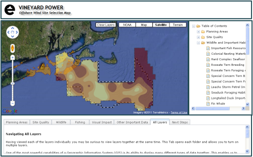
To support its members in making an informed decision Vineyard Power needed a way of distributing this data in a meaningful way to a broad audience. Using Arc2Earth for ArcGIS Desktop and Arc2Earth Cloud Services, Vineyard Power was able to export these data layers to the cloud where they could then be integrated into a Google Maps viewing application using the Arc2Earth Cloud Services REST API. You can see a screenshot of the application below. Tilesets are displayed in the viewer as the user clicks an item from the table of contents on the right hand side of the application or when clicking a subject tab just below the map.
According to Tyler Studds, Project Manager, “The functionality provided by A2E has been an incredible asset to our site selection process. The interface between cloud and desktop GIS is smooth and it has made it very easy to upload tilesets and to experiment with how they will appear in the web application.”
What is Arc2Earth Cloud Services?
Arc2Earth Cloud Services is a new ArcGIS Desktop software extension (currently in public beta testing) for uploading your existing GIS datasets to the cloud as vector datasets or tileset map caches. Once uploaded, vector datasets can be searched and edited through ArcGIS Desktop or a custom, browser based map viewer. In addition, Arc2Earth Cloud Services also provides various services including the ability to combine attribute searches with spatial operations.
As we have done with the Vineyard Power application, you can extend your data into Google Maps, Bing, and OpenLayers and build both web and mobile applications. The API is also compatible with the ArcGIS Server Open Geoservices REST specification which allows you to use all of the ArcGIS.com infrastructure, web applications, mobile applications, and web APIs with your Cloud hosted data.
Arc2Earth Cloud Services is built on Google App engine which is designed for automatic and instant scalability along with the reliability, performance, and security of Google’s infrastructure. Storage costs are dramatically reduced due to the cost efficient hosting provided by Google App engine. You only pay for the CPU/Bandwidth/Storage that you use.
Creating and Using an Arc2Earth Cloud Service
Before you can begin using Arc2Earth Cloud Services you’ll first need to create an instance which is hosted by Google App Engine. This article from Arc2Earth fully describes this process.
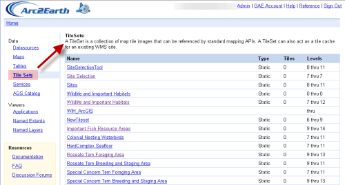
After creating an Arc2Earth Cloud instance you can then start creating Tilesets and uploading vector layers. You can then manage your instance through the interface as seen below. Here you see a listing of tilesets that have been loaded for a cloud instance.
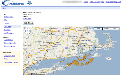
Clicking a particular tileset will display additional information including a display of the data on a Google basemap.
The Arc2Earth Cloud Services REST API
All data uploaded to an Arc2Earth Cloud instance is accessible through a standard REST API which exposes several APIs including the following:
Datasource API – Read/Write access to vector data using industry data standards
Tileset API – Read/Write access to all tile caches
Static Map API – All tilesets have built in support for combining multiple tilesets on the server to create a single static image.
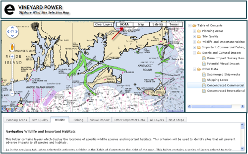
Vineyard Power published several dozen layers as individual tile caches to their unique Arc2Earth Cloud. We then used the Tileset API to access the various tiles that had been published to the Cloud and display them in a Google Maps application. In addition to using the Tileset API and the Google Maps API we also took advantage of the Dojo JavaScript framework to create the user interface and handle browser differences. Dojo widgets including the TabContainer and Tree were used to handle the display of various tilesets in the map viewer. We also created a custom base map layer for Google Maps using a NOAA tileset that was uploaded to the Arc2Earth Cloud. See the figure below.
Programming with the Tileset API
As I mentioned earlier in the article we only used the Tileset API for this particular application since we were dealing with tilesets. In future articles we’ll explore the Datasource API and Static Map API and the capabilities of each, but for now we’ll concentrate on the Tileset API.
With the Tileset API you can get a list of all tilesets for a Cloud instance, get an individual tileset, add a new tilset, delete a tileset, and bulk uploaded tiles. You can view the documentation for the Tileset API.
In the Vineyard Power application which functions solely as a map viewer the only thing we’re interested in doing is accessing tilesets from the Cloud instance. The tileset that we access depends upon the layer that has been clicked in the table of contents. Map tiles can be accessed using either the Google Maps or Microsoft Bing naming conventions as seen below.
We used the Google Maps naming convention along with the ImageMapType class from the Google Maps API v3 to add a tileset to the map. A code example is provided below. The ImageMapType class is provided for rendering image tiles such as the ones stored in our Arc2Earth Cloud instance. This class takes a parameter of type ImageMapTypeOptions which is used to set various properties of the new ImageMapType including the Url (getTileUrl) to the tileset, tilesize, if the image is a PNG, transparency value (opacity) and others. Once these parameters are set we simply call the ‘push’ method on map.overlayMapTypes to push the tileset into the Google Maps display.
There was a lot of additional code that we implemented in the application to create the tree and tab structures, layout the application, clear the layers, and add a NOAA basemap, but the primary purpose of the application was to display tilesets on a Google Maps base layer and this is pretty easy to accomplish using the Tileset API for Arc2Earth Cloud Services. In future posts we’ll take a look at other functionality provided by the Tileset API along with the Datasource API and Static Map API.
GeoSpatial Training Services is a Google Maps Qualified Developer.


