

In cadastral GIS, the accuracy and integrity of parcel boundaries are crucial for land management, taxation, and development. Two core concepts, COGO (Coordinate Geometry) and Parcel Fabric, help GIS professionals ensure that parcel data is both precisely measured and well-managed.
Understanding how COGO lines define parcel boundaries and how Parcel Fabric organizes those boundaries into polygons provides the foundation for maintaining trustworthy land records.
What is COGO in GIS?
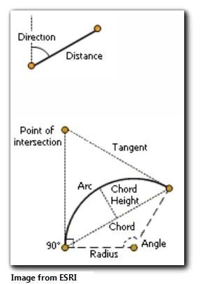
COGO stands for “Coordinate Geometry”. It refers to tools and data structures that allow GIS professionals to input and manage survey-grade measurements, such as bearings, distances, and curves, within GIS, particularly for parcel boundary lines.
Purpose:
To capture and maintain legal measurements (not just coordinates) in GIS, ensuring that parcel boundaries align with legal records.
COGO Attributes:
- Bearing (e.g., N45°E)
- Distance (e.g., 100 feet)
- Curves (radius, arc length, chord)
Purpose:
Land boundaries are defined by measurements, not just points. COGO allows GIS professionals to reflect those legal measurements directly in GIS, improving accuracy and compliance with legal documentation.
What is Parcel Fabric?
The Parcel Fabric is a data model and editing framework in ArcGIS Pro that manages parcels, easements, and related cadastral data. Every parcel change (split, merge, adjustment) is tied to a legal record, such as a deed or survey.
Key Features:
- Maintains topological relationships between parcels and related features.
- Supports historical lineage tracking (who changed what and when).
- Designed for multi-user editing in enterprise GIS environments.
Purpose:
To ensure data integrity, historical accuracy, attribute (bearing, distance, curves) tracking, and legal defensibility in managing land records.
COGO and Parcel Fabric ArcGIS Pro Licensing Requirements
COGO and Parcel Fabric are available in ArcGIS Pro with either a Standard or Advanced license, without the need for additional extensions. The only exception is when implementing Parcel Fabric in a multi-user editing environment, which requires ArcGIS Enterprise to support enterprise geodatabases.
| Functionality | ArcGIS Pro Basic | ArcGIS Pro Standard | ArcGIS Pro Advanced | ArcGIS Enterprise Required |
|---|---|---|---|---|
| COGO Attributes (Lines) | ❌ | ✅ | ✅ | ❌ |
| Traverse Tool (COGO) | ❌ | ✅ | ✅ | ❌ |
| Parcel Fabric (Single-user, File GDB) | ❌ | ✅ | ✅ | ❌ |
| Parcel Fabric (Multi-user, Enterprise GDB) | ❌ | ✅ | ✅ | ✅ |
COGO Tools: Traverse vs. COGO
COGO refers to the data model that stores survey measurements (bearing, distance, curves) along boundary lines.
Traverse is a tool in ArcGIS Pro that allows GIS professionals to input these measurements step by step, just as a surveyor would record them in the field.
The COGO Editor can also be used to manually edit COGO attributes on individual lines.
Key takeaway:
- COGO is the data structure (attributes).
- Traverse is the workflow tool used to create and maintain that structure.
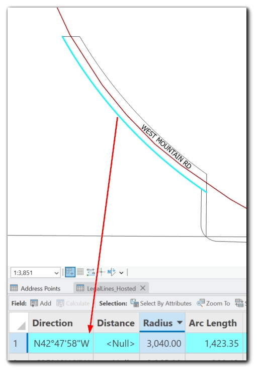
COGO Lines vs. Non-COGO Lines: Accuracy Matters
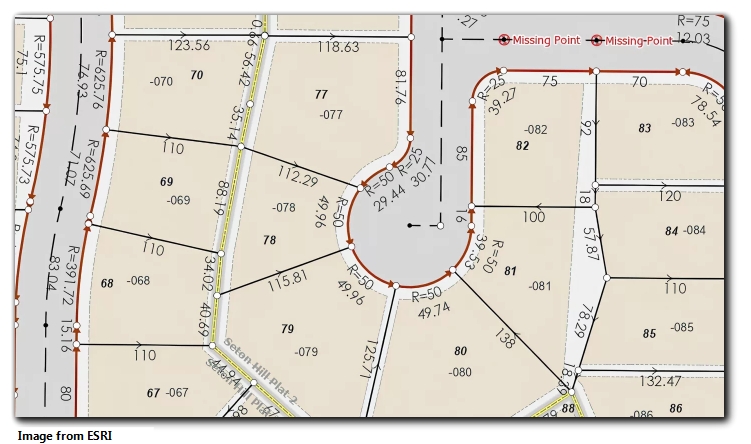
In most cases, parcel boundaries are represented by lines. These lines are the foundation for creating parcel polygons, and their accuracy directly affects the reliability of the entire parcel dataset.
COGO Lines:
- Store survey-derived measurements (bearing, distance, curves).
- Created and maintained using COGO tools like the Traverse tool or COGO Editor in ArcGIS Pro.
- Prioritize measurement accuracy and legal alignment.
- Can be reconstructed from measurements, ensuring that the geometry reflects survey records.
Non-COGO Lines:
- Represent digitized geometries without survey measurements.
- Store only coordinates (x, y)—no bearings, distances, or curve data.
- Created by digitizing over imagery or importing non-survey data (e.g., shapefiles, CAD).
- Cannot be reconstructed from survey measurements, limiting precision.
Key takeaway:
COGO lines focus on legal and measurement accuracy; non-COGO lines focus on visual representation but may lack survey-grade precision.
Over time, GIS professionals can enhance data quality by converting non-COGO lines to COGO lines as survey records become available.
COGO Lines vs. Parcel Polygons: Distinct Layers, Connected Data
While COGO lines define parcel boundaries, they exist only in polyline layers. COGO functionality applies exclusively to lines—not polygons.
Lines (Polylines):
- Store COGO attributes (bearings, distances, curves).
- Define the edges of parcels.
Parcel Polygons:
- Represent the area of parcels (used for land ownership, assessment, visualization).
- Constructed from the network of boundary lines (both COGO and non-COGO).
- Must be updated when boundary lines are edited.
Important distinction:
COGO does not construct parcel polygons directly. Polygons are built from lines, and the accuracy of those polygons depends entirely on the boundary lines’ precision.
Example Workflows: Parcel Fabric vs. Non-Parcel Fabric
Workflow 1: Using Parcel Fabric
- Load Parcel Fabric Dataset:
Work within an ArcGIS Pro Parcel Fabric that manages parcels as lines and polygons. - Input or Edit Boundary Lines:
Use Traverse to input COGO-enabled lines based on survey measurements.
Validate topological connections between lines (ensure closed loops). - Build Parcel Polygons:
Use the Build Parcels tool to generate polygons from the network of boundary lines. - Tie to Legal Records:
Record lineage (splits, merges) and associate changes with legal documents (e.g., deeds, plats). - Maintain Over Time:
Use Parcel Fabric’s versioning and history tracking to manage ongoing changes, supporting multi-user editing.
Workflow 2: Without Parcel Fabric (Simple GIS Environment)
- Manually Input COGO Data:
If available, COGO attributes can be manually added to polyline layers for parcel boundaries.
Use Traverse to input boundary lines with measurements. - Manually Update Individual Parcels:
Any splits, merges, or adjustments require manual edits to the polygons (copying, tracing, reshaping).
There’s no historical record tracking or topological enforcement.
Key Differences:
Parcel Fabric:
- Maintains topology, history, and lineage.
- Provides structured workflows for parcel polygon management.
- Supports COGO measurements integrated with parcel lines.
Non-Parcel Fabric:
- No topological enforcement or record tracking.
- COGO can exist independently, but polygons must be managed manually.
- Supports COGO measurements integrated with parcel lines.
- Simpler but less scalable for complex cadastral systems.
Why This Matters for GIS Professionals
For GIS professionals working with land records, there are multiple pathways to managing parcel boundaries and cadastral data. COGO and Parcel Fabric are two tools that can work together or independently, depending on the complexity and needs of your system.
-
COGO provides survey-grade precision for line features, whether those lines exist within Parcel Fabric or as standalone polyline layers. This flexibility allows GIS professionals to maintain accurate geometries tied to legal survey measurements in any dataset.
-
Parcel Fabric is not strictly necessary for managing parcel data but offers structured workflows that streamline the editing, tracking, and historical management of parcels over time. It integrates COGO measurements, topology, and record-driven lineage tracking, making it a powerful option for more complex cadastral environments.
Choosing the right approach depends on the scale, complexity, and legal requirements of your parcel management system:
-
In simpler systems, parcels can be maintained as standalone polygons, with COGO attributes applied directly to lines as needed.
-
In more complex systems, Parcel Fabric provides additional functionality for multi-user editing, topological integrity, and historical tracking.
Regardless of the approach, COGO ensures precision, and Parcel Fabric offers structured management—together or separately, they support accurate and legally aligned parcel data.
