Webinar – Hot Spot Analysis with ArcGIS

by | Sep 26, 2016

Join us for a free webinar on Monday, November 21st.  In this webinar we’ll cover the use of the Hot Spot Analysis tool in ArcGIS.

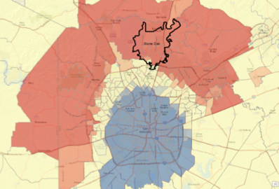
The Hot Spot Analysis tool in ArcGIS examines features and their attributes to identify statistically significant hot spots and cold spots using the Getis-Ord Gi* stats. It provides a visual clustering of high, low and not significant values. Each feature is assigned as a hot spot, cold spot, or not significant. To perform the analysis, a neighborhood is defined for each feature. How a neighborhood is defined is critical to the output of the tool as it is the neighborhood that is examined in relation to the study area for assignment of each feature.

Register here.

Categories

Recent Posts

Eric Pimpler
Eric is the founder and owner of GeoSpatial Training Services (geospatialtraining.com) and has over 25 years of experience implementing and teaching GIS solutions using ESRI, Google Earth/Maps, Open Source technology. Currently Eric focuses on ArcGIS scripting with Python, and the development of custom ArcGIS Server web and mobile applications using JavaScript. Eric is the author of Programming ArcGIS with Python Cookbook - 1st and 2nd Edition, Building Web and Mobile ArcGIS Server Applications with JavaScript, Spatial Analytics with ArcGIS, and ArcGIS Blueprints. Eric has a Bachelor’s degree in Geography from Texas A&M University and a Master's of Applied Geography degree with a concentration in GIS from Texas State University.

Sign up for our weekly newsletter
to receive content like this in your email box.